You are here: Home > Network List > GE - GEOFON Stations List
> Station IBBN RUB/GEOFON Station Ibbenbueren, Germany > Earthquake Result Viewer
IBBN RUB/GEOFON Station Ibbenbueren, Germany - Earthquake Result Viewer
| Earthquake location: |
Tajikistan |
| Earthquake latitude/longitude: |
38.1/72.7 |
| Earthquake time(UTC): |
2005/02/25 (056) 23:04:04 GMT |
| Earthquake Depth: |
115 km |
| Earthquake Magnitude: |
6.1 MB, 5.7 MW, 5.7 MW |
| Earthquake Catalog/Contributor: |
WHDF/NEIC |
|
| Network: |
GE GEOFON |
| Station: |
IBBN RUB/GEOFON Station Ibbenbueren, Germany |
| Lat/Lon: |
52.31 N/7.76 E |
| Elevation: |
140 m |
|
| Distance: |
46.4 deg |
| Az: |
309.766 deg |
| Baz: |
80.96 deg |
| Ray Param: |
0.070298284 |
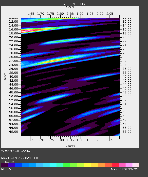
| Estimated Moho Depth: |
16.75 km |
| Estimated Crust Vp/Vs: |
1.60 |
| Assumed Crust Vp: |
6.1 km/s |
| Estimated Crust Vs: |
3.812 km/s |
| Estimated Crust Poisson's Ratio: |
0.18 |
|
| Radial Match: |
81.2286 % |
| Radial Bump: |
400 |
| Transverse Match: |
74.39529 % |
| Transverse Bump: |
400 |
| SOD ConfigId: |
2455 |
| Insert Time: |
2010-03-09 06:38:43.126 +0000 |
| GWidth: |
2.5 |
| Max Bumps: |
400 |
| Tol: |
0.001 |
|

Signal To Noise
| Channel | StoN | STA | LTA |
| GE:IBBN: :BHN:20050225T23:11:48.171001Z | 10.139131 | 1.4236315E-6 | 1.4040961E-7 |
| GE:IBBN: :BHE:20050225T23:11:48.171001Z | 9.896934 | 1.3167096E-6 | 1.3304218E-7 |
| GE:IBBN: :BHZ:20050225T23:11:48.171001Z | 26.028095 | 2.6514538E-6 | 1.01868906E-7 |
| Arrivals |
| Ps | 1.8 SECOND |
| PpPs | 6.7 SECOND |
| PsPs/PpSs | 8.5 SECOND |


