You are here: Home > Network List > TA - USArray Transportable Network (new EarthScope stations) Stations List
> Station F26K Sheenjek River, AK, USA > Earthquake Result Viewer
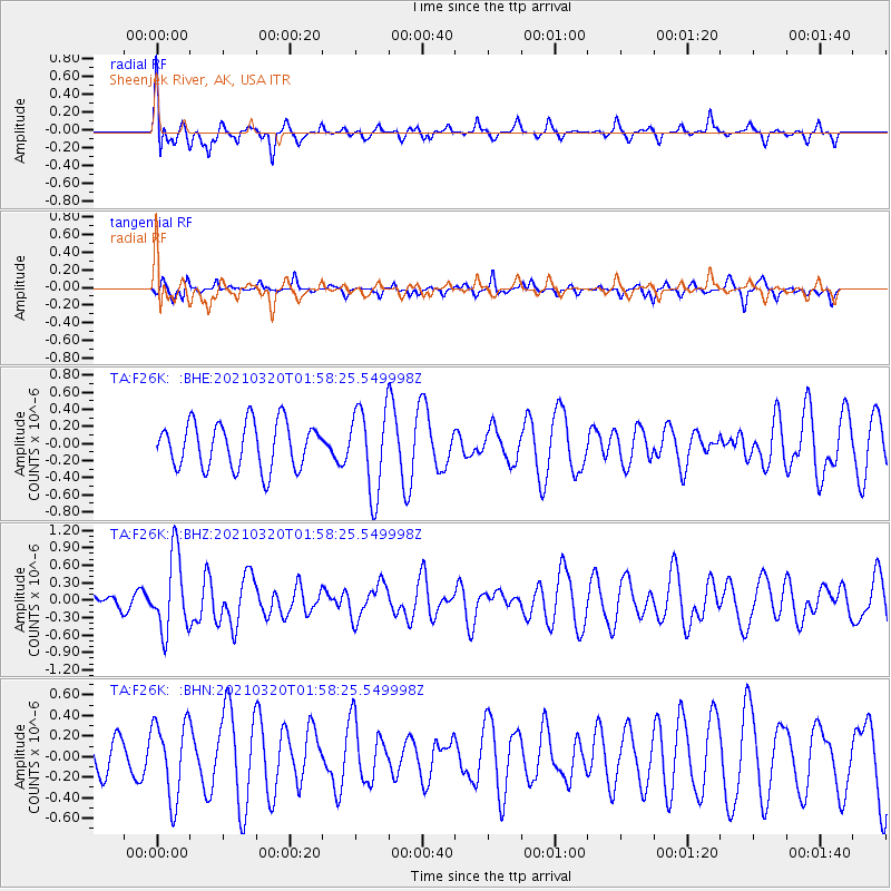
F26K Sheenjek River, AK, USA - Earthquake Result Viewer
*The percent match for this event was below the threshold and hence no stack was calculated.
| Earthquake location: |
Northern Mid-Atlantic Ridge |
| Earthquake latitude/longitude: |
47.3/-27.3 |
| Earthquake time(UTC): |
2021/03/20 (079) 01:49:18 GMT |
| Earthquake Depth: |
10 km |
| Earthquake Magnitude: |
5.8 Mww |
| Earthquake Catalog/Contributor: |
NEIC PDE/us |
|
| Network: |
TA USArray Transportable Network (new EarthScope stations) |
| Station: |
F26K Sheenjek River, AK, USA |
| Lat/Lon: |
67.69 N/144.15 W |
| Elevation: |
683 m |
|
| Distance: |
56.0 deg |
| Az: |
335.732 deg |
| Baz: |
47.14 deg |
| Ray Param: |
$rayparam |
*The percent match for this event was below the threshold and hence was not used in the summary stack. |
|
| Radial Match: |
58.096577 % |
| Radial Bump: |
375 |
| Transverse Match: |
53.747696 % |
| Transverse Bump: |
299 |
| SOD ConfigId: |
24334971 |
| Insert Time: |
2021-04-03 02:11:42.632 +0000 |
| GWidth: |
2.5 |
| Max Bumps: |
400 |
| Tol: |
0.001 |
|
Signal To Noise
| Channel | StoN | STA | LTA |
| TA:F26K: :BHZ:20210320T01:58:25.549998Z | 4.5825887 | 6.578372E-7 | 1.4355143E-7 |
| TA:F26K: :BHN:20210320T01:58:25.549998Z | 2.126491 | 3.7571095E-7 | 1.7668118E-7 |
| TA:F26K: :BHE:20210320T01:58:25.549998Z | 1.855093 | 4.9441803E-7 | 2.665193E-7 |
| Arrivals |
| Ps | |
| PpPs | |
| PsPs/PpSs | |


