You are here: Home > Network List > TA - USArray Transportable Network (new EarthScope stations) Stations List
> Station G21K Allakaket, AK, USA > Earthquake Result Viewer
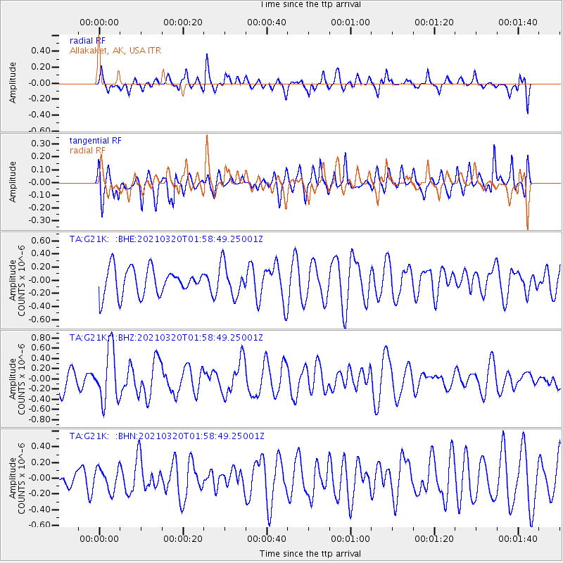
G21K Allakaket, AK, USA - Earthquake Result Viewer
*The percent match for this event was below the threshold and hence no stack was calculated.
| Earthquake location: |
Northern Mid-Atlantic Ridge |
| Earthquake latitude/longitude: |
47.3/-27.3 |
| Earthquake time(UTC): |
2021/03/20 (079) 01:49:18 GMT |
| Earthquake Depth: |
10 km |
| Earthquake Magnitude: |
5.8 Mww |
| Earthquake Catalog/Contributor: |
NEIC PDE/us |
|
| Network: |
TA USArray Transportable Network (new EarthScope stations) |
| Station: |
G21K Allakaket, AK, USA |
| Lat/Lon: |
66.52 N/153.51 W |
| Elevation: |
446 m |
|
| Distance: |
59.3 deg |
| Az: |
337.917 deg |
| Baz: |
39.692 deg |
| Ray Param: |
$rayparam |
*The percent match for this event was below the threshold and hence was not used in the summary stack. |
|
| Radial Match: |
54.374523 % |
| Radial Bump: |
400 |
| Transverse Match: |
38.756878 % |
| Transverse Bump: |
400 |
| SOD ConfigId: |
24334971 |
| Insert Time: |
2021-04-03 02:11:52.344 +0000 |
| GWidth: |
2.5 |
| Max Bumps: |
400 |
| Tol: |
0.001 |
|
Signal To Noise
| Channel | StoN | STA | LTA |
| TA:G21K: :BHZ:20210320T01:58:49.25001Z | 3.5255482 | 5.2725153E-7 | 1.4955164E-7 |
| TA:G21K: :BHN:20210320T01:58:49.25001Z | 0.69127923 | 1.4624817E-7 | 2.1156164E-7 |
| TA:G21K: :BHE:20210320T01:58:49.25001Z | 1.203162 | 2.45462E-7 | 2.0401407E-7 |
| Arrivals |
| Ps | |
| PpPs | |
| PsPs/PpSs | |


