You are here: Home > Network List > TA - USArray Transportable Network (new EarthScope stations) Stations List
> Station I30M Mount Dempster, Yukon, CAN > Earthquake Result Viewer
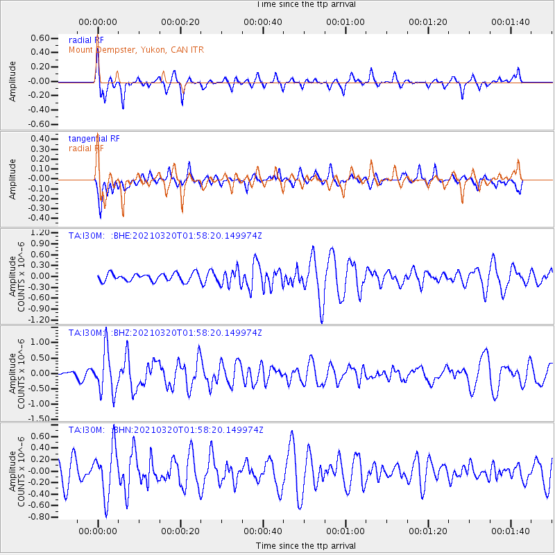
I30M Mount Dempster, Yukon, CAN - Earthquake Result Viewer
*The percent match for this event was below the threshold and hence no stack was calculated.
| Earthquake location: |
Northern Mid-Atlantic Ridge |
| Earthquake latitude/longitude: |
47.3/-27.3 |
| Earthquake time(UTC): |
2021/03/20 (079) 01:49:18 GMT |
| Earthquake Depth: |
10 km |
| Earthquake Magnitude: |
5.8 Mww |
| Earthquake Catalog/Contributor: |
NEIC PDE/us |
|
| Network: |
TA USArray Transportable Network (new EarthScope stations) |
| Station: |
I30M Mount Dempster, Yukon, CAN |
| Lat/Lon: |
65.22 N/136.38 W |
| Elevation: |
1399 m |
|
| Distance: |
55.2 deg |
| Az: |
330.99 deg |
| Baz: |
51.577 deg |
| Ray Param: |
$rayparam |
*The percent match for this event was below the threshold and hence was not used in the summary stack. |
|
| Radial Match: |
64.551315 % |
| Radial Bump: |
309 |
| Transverse Match: |
52.144127 % |
| Transverse Bump: |
400 |
| SOD ConfigId: |
24334971 |
| Insert Time: |
2021-04-03 02:12:08.483 +0000 |
| GWidth: |
2.5 |
| Max Bumps: |
400 |
| Tol: |
0.001 |
|
Signal To Noise
| Channel | StoN | STA | LTA |
| TA:I30M: :BHZ:20210320T01:58:20.149974Z | 5.072561 | 6.979033E-7 | 1.3758402E-7 |
| TA:I30M: :BHN:20210320T01:58:20.149974Z | 1.5607182 | 4.279967E-7 | 2.7423062E-7 |
| TA:I30M: :BHE:20210320T01:58:20.149974Z | 2.0110214 | 2.1350995E-7 | 1.0616991E-7 |
| Arrivals |
| Ps | |
| PpPs | |
| PsPs/PpSs | |


