You are here: Home > Network List > TX - Texas Seismological Network Stations List
> Station WTFS Witchita Falls > Earthquake Result Viewer
WTFS Witchita Falls - Earthquake Result Viewer
*The percent match for this event was below the threshold and hence no stack was calculated.
| Earthquake location: |
Northern Mid-Atlantic Ridge |
| Earthquake latitude/longitude: |
47.3/-27.3 |
| Earthquake time(UTC): |
2021/03/20 (079) 01:49:18 GMT |
| Earthquake Depth: |
10 km |
| Earthquake Magnitude: |
5.8 Mww |
| Earthquake Catalog/Contributor: |
NEIC PDE/us |
|
| Network: |
TX Texas Seismological Network |
| Station: |
WTFS Witchita Falls |
| Lat/Lon: |
33.77 N/98.46 W |
| Elevation: |
277 m |
|
| Distance: |
54.0 deg |
| Az: |
282.832 deg |
| Baz: |
52.83 deg |
| Ray Param: |
$rayparam |
*The percent match for this event was below the threshold and hence was not used in the summary stack. |
|
| Radial Match: |
77.12646 % |
| Radial Bump: |
307 |
| Transverse Match: |
71.24567 % |
| Transverse Bump: |
368 |
| SOD ConfigId: |
24334971 |
| Insert Time: |
2021-04-03 02:14:20.136 +0000 |
| GWidth: |
2.5 |
| Max Bumps: |
400 |
| Tol: |
0.001 |
|
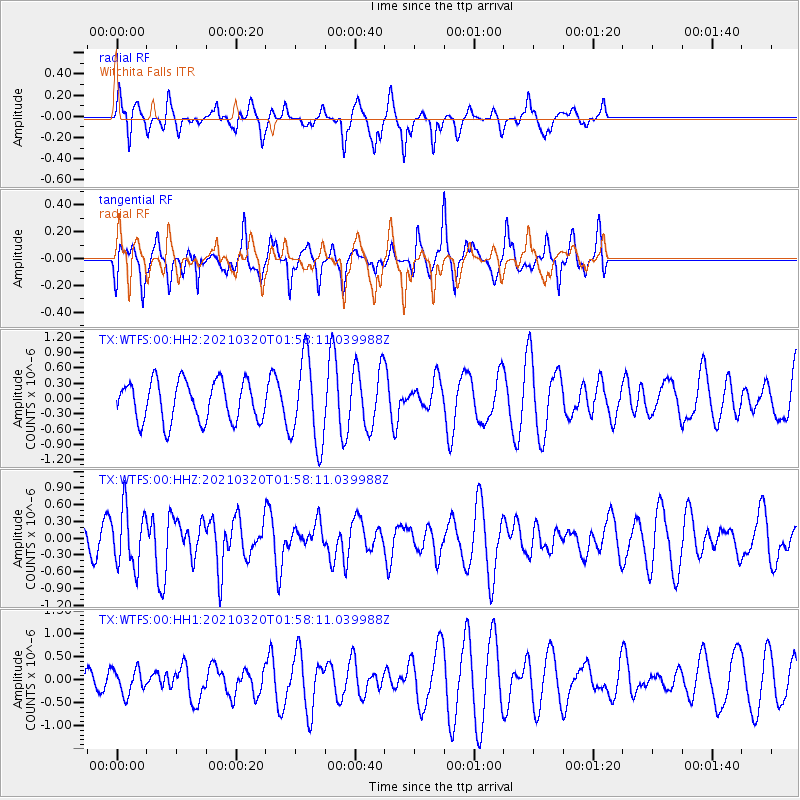
Signal To Noise
| Channel | StoN | STA | LTA |
| TX:WTFS:00:HHZ:20210320T01:58:11.039988Z | 2.4765897 | 5.1357836E-7 | 2.073732E-7 |
| TX:WTFS:00:HH1:20210320T01:58:11.039988Z | 0.48802802 | 2.69158E-7 | 5.515216E-7 |
| TX:WTFS:00:HH2:20210320T01:58:11.039988Z | 2.1651928 | 8.445052E-7 | 3.9003697E-7 |
| Arrivals |
| Ps | |
| PpPs | |
| PsPs/PpSs | |


