You are here: Home > Network List > US - United States National Seismic Network Stations List
> Station BOZ Bozeman, Montana, USA > Earthquake Result Viewer
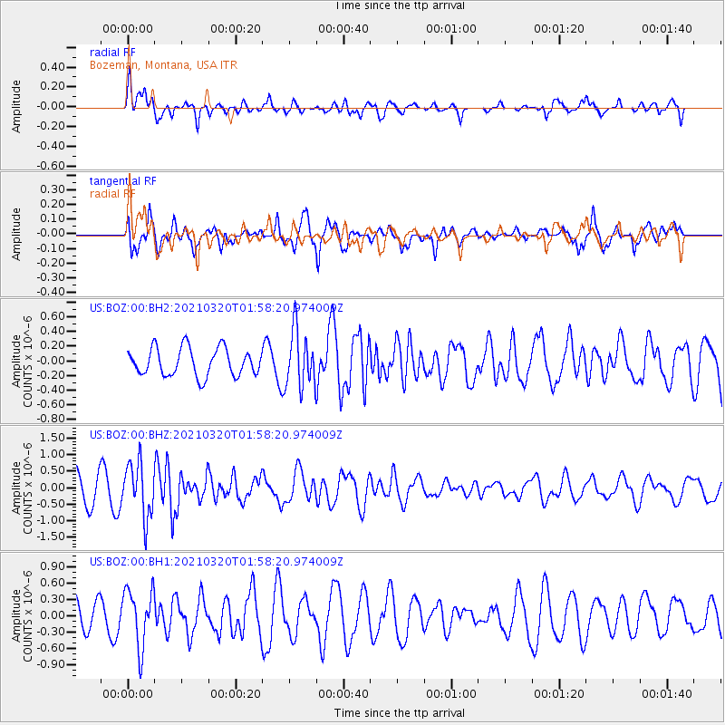
BOZ Bozeman, Montana, USA - Earthquake Result Viewer
*The percent match for this event was below the threshold and hence no stack was calculated.
| Earthquake location: |
Northern Mid-Atlantic Ridge |
| Earthquake latitude/longitude: |
47.3/-27.3 |
| Earthquake time(UTC): |
2021/03/20 (079) 01:49:18 GMT |
| Earthquake Depth: |
10 km |
| Earthquake Magnitude: |
5.8 Mww |
| Earthquake Catalog/Contributor: |
NEIC PDE/us |
|
| Network: |
US United States National Seismic Network |
| Station: |
BOZ Bozeman, Montana, USA |
| Lat/Lon: |
45.65 N/111.63 W |
| Elevation: |
1589 m |
|
| Distance: |
55.3 deg |
| Az: |
301.894 deg |
| Baz: |
55.488 deg |
| Ray Param: |
$rayparam |
*The percent match for this event was below the threshold and hence was not used in the summary stack. |
|
| Radial Match: |
59.575134 % |
| Radial Bump: |
400 |
| Transverse Match: |
76.275154 % |
| Transverse Bump: |
400 |
| SOD ConfigId: |
24334971 |
| Insert Time: |
2021-04-03 02:14:54.791 +0000 |
| GWidth: |
2.5 |
| Max Bumps: |
400 |
| Tol: |
0.001 |
|
Signal To Noise
| Channel | StoN | STA | LTA |
| US:BOZ:00:BHZ:20210320T01:58:20.974009Z | 2.3958676 | 8.234731E-7 | 3.437056E-7 |
| US:BOZ:00:BH1:20210320T01:58:20.974009Z | 1.462366 | 5.395177E-7 | 3.689348E-7 |
| US:BOZ:00:BH2:20210320T01:58:20.974009Z | 2.036665 | 3.84114E-7 | 1.8859951E-7 |
| Arrivals |
| Ps | |
| PpPs | |
| PsPs/PpSs | |


