You are here: Home > Network List > US - United States National Seismic Network Stations List
> Station CBKS Cedar Bluff, Kansas, USA > Earthquake Result Viewer
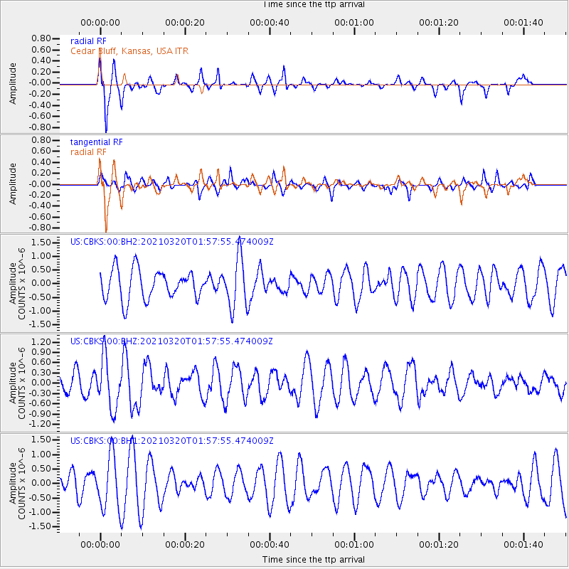
CBKS Cedar Bluff, Kansas, USA - Earthquake Result Viewer
*The percent match for this event was below the threshold and hence no stack was calculated.
| Earthquake location: |
Northern Mid-Atlantic Ridge |
| Earthquake latitude/longitude: |
47.3/-27.3 |
| Earthquake time(UTC): |
2021/03/20 (079) 01:49:18 GMT |
| Earthquake Depth: |
10 km |
| Earthquake Magnitude: |
5.8 Mww |
| Earthquake Catalog/Contributor: |
NEIC PDE/us |
|
| Network: |
US United States National Seismic Network |
| Station: |
CBKS Cedar Bluff, Kansas, USA |
| Lat/Lon: |
38.81 N/99.74 W |
| Elevation: |
677 m |
|
| Distance: |
51.8 deg |
| Az: |
288.71 deg |
| Baz: |
55.627 deg |
| Ray Param: |
$rayparam |
*The percent match for this event was below the threshold and hence was not used in the summary stack. |
|
| Radial Match: |
70.544426 % |
| Radial Bump: |
310 |
| Transverse Match: |
45.204823 % |
| Transverse Bump: |
311 |
| SOD ConfigId: |
24334971 |
| Insert Time: |
2021-04-03 02:14:57.133 +0000 |
| GWidth: |
2.5 |
| Max Bumps: |
400 |
| Tol: |
0.001 |
|
Signal To Noise
| Channel | StoN | STA | LTA |
| US:CBKS:00:BHZ:20210320T01:57:55.474009Z | 2.722933 | 7.4193565E-7 | 2.7247665E-7 |
| US:CBKS:00:BH1:20210320T01:57:55.474009Z | 2.0079095 | 9.37594E-7 | 4.6695033E-7 |
| US:CBKS:00:BH2:20210320T01:57:55.474009Z | 1.7750002 | 9.398298E-7 | 5.294815E-7 |
| Arrivals |
| Ps | |
| PpPs | |
| PsPs/PpSs | |


