You are here: Home > Network List > US - United States National Seismic Network Stations List
> Station EGMT Eagleton, Montana, USA > Earthquake Result Viewer
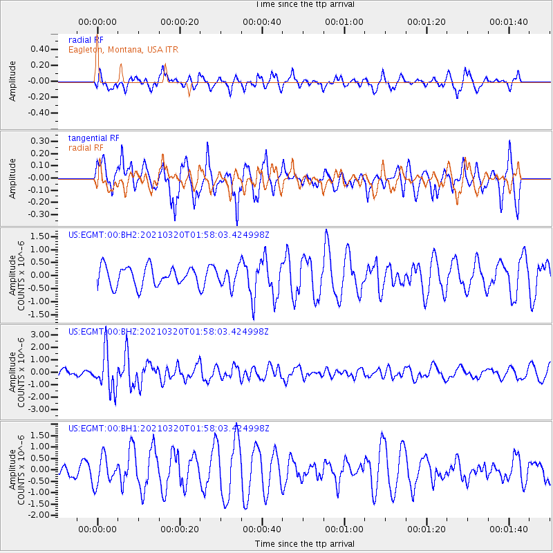
EGMT Eagleton, Montana, USA - Earthquake Result Viewer
*The percent match for this event was below the threshold and hence no stack was calculated.
| Earthquake location: |
Northern Mid-Atlantic Ridge |
| Earthquake latitude/longitude: |
47.3/-27.3 |
| Earthquake time(UTC): |
2021/03/20 (079) 01:49:18 GMT |
| Earthquake Depth: |
10 km |
| Earthquake Magnitude: |
5.8 Mww |
| Earthquake Catalog/Contributor: |
NEIC PDE/us |
|
| Network: |
US United States National Seismic Network |
| Station: |
EGMT Eagleton, Montana, USA |
| Lat/Lon: |
48.02 N/109.75 W |
| Elevation: |
1055 m |
|
| Distance: |
52.9 deg |
| Az: |
303.471 deg |
| Baz: |
57.776 deg |
| Ray Param: |
$rayparam |
*The percent match for this event was below the threshold and hence was not used in the summary stack. |
|
| Radial Match: |
68.13475 % |
| Radial Bump: |
400 |
| Transverse Match: |
75.26596 % |
| Transverse Bump: |
400 |
| SOD ConfigId: |
24334971 |
| Insert Time: |
2021-04-03 02:15:03.266 +0000 |
| GWidth: |
2.5 |
| Max Bumps: |
400 |
| Tol: |
0.001 |
|
Signal To Noise
| Channel | StoN | STA | LTA |
| US:EGMT:00:BHZ:20210320T01:58:03.424998Z | 6.7659116 | 1.5769032E-6 | 2.3306589E-7 |
| US:EGMT:00:BH1:20210320T01:58:03.424998Z | 1.5115483 | 6.09054E-7 | 4.0293384E-7 |
| US:EGMT:00:BH2:20210320T01:58:03.424998Z | 1.0008292 | 3.6662735E-7 | 3.6632358E-7 |
| Arrivals |
| Ps | |
| PpPs | |
| PsPs/PpSs | |


