You are here: Home > Network List > US - United States National Seismic Network Stations List
> Station MSO Missoula, Montana, USA > Earthquake Result Viewer
MSO Missoula, Montana, USA - Earthquake Result Viewer
*The percent match for this event was below the threshold and hence no stack was calculated.
| Earthquake location: |
Northern Mid-Atlantic Ridge |
| Earthquake latitude/longitude: |
47.3/-27.3 |
| Earthquake time(UTC): |
2021/03/20 (079) 01:49:18 GMT |
| Earthquake Depth: |
10 km |
| Earthquake Magnitude: |
5.8 Mww |
| Earthquake Catalog/Contributor: |
NEIC PDE/us |
|
| Network: |
US United States National Seismic Network |
| Station: |
MSO Missoula, Montana, USA |
| Lat/Lon: |
46.83 N/113.94 W |
| Elevation: |
1264 m |
|
| Distance: |
55.9 deg |
| Az: |
304.178 deg |
| Baz: |
55.114 deg |
| Ray Param: |
$rayparam |
*The percent match for this event was below the threshold and hence was not used in the summary stack. |
|
| Radial Match: |
41.00065 % |
| Radial Bump: |
327 |
| Transverse Match: |
59.33666 % |
| Transverse Bump: |
400 |
| SOD ConfigId: |
24334971 |
| Insert Time: |
2021-04-03 02:15:19.927 +0000 |
| GWidth: |
2.5 |
| Max Bumps: |
400 |
| Tol: |
0.001 |
|
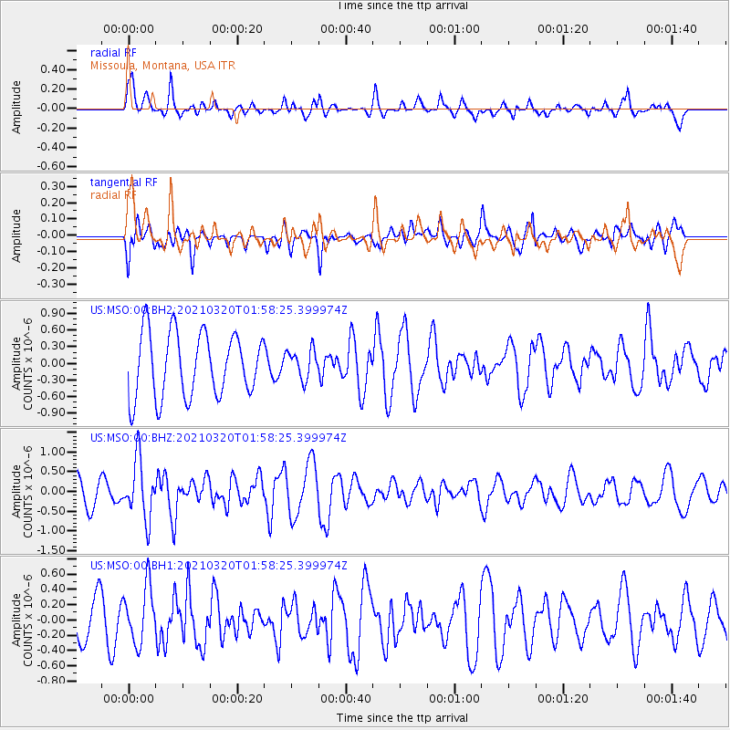
Signal To Noise
| Channel | StoN | STA | LTA |
| US:MSO:00:BHZ:20210320T01:58:25.399974Z | 1.9194026 | 7.4780286E-7 | 3.8960187E-7 |
| US:MSO:00:BH1:20210320T01:58:25.399974Z | 1.4915819 | 3.7111002E-7 | 2.4880296E-7 |
| US:MSO:00:BH2:20210320T01:58:25.399974Z | 0.45433834 | 2.630618E-7 | 5.7899973E-7 |
| Arrivals |
| Ps | |
| PpPs | |
| PsPs/PpSs | |


