You are here: Home > Network List > US - United States National Seismic Network Stations List
> Station LONY Lake Ozonia, New York, USA > Earthquake Result Viewer
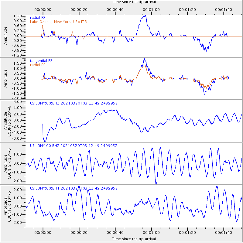
LONY Lake Ozonia, New York, USA - Earthquake Result Viewer
*The percent match for this event was below the threshold and hence no stack was calculated.
| Earthquake location: |
Near Coast Of Guerrero, Mexico |
| Earthquake latitude/longitude: |
16.7/-98.8 |
| Earthquake time(UTC): |
2021/03/20 (079) 03:06:33 GMT |
| Earthquake Depth: |
28 km |
| Earthquake Magnitude: |
5.7 Mww |
| Earthquake Catalog/Contributor: |
NEIC PDE/us |
|
| Network: |
US United States National Seismic Network |
| Station: |
LONY Lake Ozonia, New York, USA |
| Lat/Lon: |
44.62 N/74.58 W |
| Elevation: |
440 m |
|
| Distance: |
34.6 deg |
| Az: |
31.116 deg |
| Baz: |
223.921 deg |
| Ray Param: |
$rayparam |
*The percent match for this event was below the threshold and hence was not used in the summary stack. |
|
| Radial Match: |
20.11306 % |
| Radial Bump: |
400 |
| Transverse Match: |
31.310856 % |
| Transverse Bump: |
400 |
| SOD ConfigId: |
24334971 |
| Insert Time: |
2021-04-03 03:18:49.824 +0000 |
| GWidth: |
2.5 |
| Max Bumps: |
400 |
| Tol: |
0.001 |
|
Signal To Noise
| Channel | StoN | STA | LTA |
| US:LONY:00:BHZ:20210320T03:12:49.249995Z | 0.92210436 | 5.1928805E-7 | 5.6315537E-7 |
| US:LONY:00:BH1:20210320T03:12:49.249995Z | 1.4062905 | 1.0378108E-6 | 7.3797753E-7 |
| US:LONY:00:BH2:20210320T03:12:49.249995Z | 2.3309295 | 4.353637E-6 | 1.8677686E-6 |
| Arrivals |
| Ps | |
| PpPs | |
| PsPs/PpSs | |


