You are here: Home > Network List > TX - Texas Seismological Network Stations List
> Station FW06 Azle > Earthquake Result Viewer
FW06 Azle - Earthquake Result Viewer
| Earthquake location: |
Tonga Islands |
| Earthquake latitude/longitude: |
-15.4/-173.2 |
| Earthquake time(UTC): |
2017/11/04 (308) 09:00:19 GMT |
| Earthquake Depth: |
10 km |
| Earthquake Magnitude: |
6.8 Mww |
| Earthquake Catalog/Contributor: |
NEIC PDE/us |
|
| Network: |
TX Texas Seismological Network |
| Station: |
FW06 Azle |
| Lat/Lon: |
32.97 N/97.56 W |
| Elevation: |
233 m |
|
| Distance: |
86.7 deg |
| Az: |
54.666 deg |
| Baz: |
249.437 deg |
| Ray Param: |
0.04389071 |
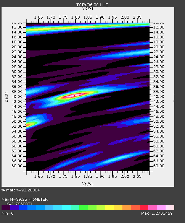
| Estimated Moho Depth: |
39.25 km |
| Estimated Crust Vp/Vs: |
1.80 |
| Assumed Crust Vp: |
6.38 km/s |
| Estimated Crust Vs: |
3.555 km/s |
| Estimated Crust Poisson's Ratio: |
0.27 |
|
| Radial Match: |
93.20804 % |
| Radial Bump: |
307 |
| Transverse Match: |
90.557106 % |
| Transverse Bump: |
400 |
| SOD ConfigId: |
2429771 |
| Insert Time: |
2017-11-18 09:06:48.730 +0000 |
| GWidth: |
2.5 |
| Max Bumps: |
400 |
| Tol: |
0.001 |
|

Signal To Noise
| Channel | StoN | STA | LTA |
| TX:FW06:00:HHZ:20171104T09:12:32.159993Z | 18.315279 | 2.5878228E-6 | 1.4129311E-7 |
| TX:FW06:00:HH1:20171104T09:12:32.159993Z | 1.7126287 | 1.9698145E-7 | 1.15017016E-7 |
| TX:FW06:00:HH2:20171104T09:12:32.159993Z | 4.595029 | 6.776208E-7 | 1.4746823E-7 |
| Arrivals |
| Ps | 5.0 SECOND |
| PpPs | 17 SECOND |
| PsPs/PpSs | 22 SECOND |


