You are here: Home > Network List > UU - University of Utah Regional Network Stations List
> Station KNB Kanab, UT, USA > Earthquake Result Viewer
KNB Kanab, UT, USA - Earthquake Result Viewer
*The percent match for this event was below the threshold and hence no stack was calculated.
| Earthquake location: |
South Of Tonga Islands |
| Earthquake latitude/longitude: |
-24.6/-175.9 |
| Earthquake time(UTC): |
2021/03/20 (079) 05:09:36 GMT |
| Earthquake Depth: |
19 km |
| Earthquake Magnitude: |
5.5 Mww |
| Earthquake Catalog/Contributor: |
NEIC PDE/us |
|
| Network: |
UU University of Utah Regional Network |
| Station: |
KNB Kanab, UT, USA |
| Lat/Lon: |
37.02 N/112.82 W |
| Elevation: |
1715 m |
|
| Distance: |
85.3 deg |
| Az: |
45.72 deg |
| Baz: |
234.479 deg |
| Ray Param: |
$rayparam |
*The percent match for this event was below the threshold and hence was not used in the summary stack. |
|
| Radial Match: |
73.57993 % |
| Radial Bump: |
400 |
| Transverse Match: |
62.138023 % |
| Transverse Bump: |
375 |
| SOD ConfigId: |
24334971 |
| Insert Time: |
2021-04-03 05:27:21.303 +0000 |
| GWidth: |
2.5 |
| Max Bumps: |
400 |
| Tol: |
0.001 |
|
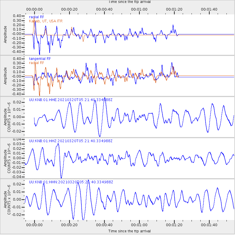
Signal To Noise
| Channel | StoN | STA | LTA |
| UU:KNB:01:HHZ:20210320T05:21:40.334988Z | 2.8265116 | 1.6941788E-8 | 5.993886E-9 |
| UU:KNB:01:HHN:20210320T05:21:40.334988Z | 0.8163306 | 8.1402955E-9 | 9.971813E-9 |
| UU:KNB:01:HHE:20210320T05:21:40.334988Z | 1.1541085 | 1.0441014E-8 | 9.046821E-9 |
| Arrivals |
| Ps | |
| PpPs | |
| PsPs/PpSs | |


