You are here: Home > Network List > TX - Texas Seismological Network Stations List
> Station FW16 Waxahatchie > Earthquake Result Viewer
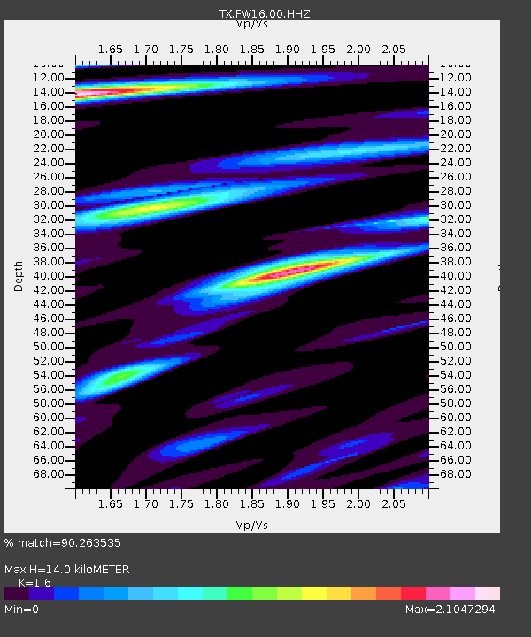
FW16 Waxahatchie - Earthquake Result Viewer
| Earthquake location: |
Tonga Islands |
| Earthquake latitude/longitude: |
-15.4/-173.2 |
| Earthquake time(UTC): |
2017/11/04 (308) 09:00:19 GMT |
| Earthquake Depth: |
10 km |
| Earthquake Magnitude: |
6.8 Mww |
| Earthquake Catalog/Contributor: |
NEIC PDE/us |
|
| Network: |
TX Texas Seismological Network |
| Station: |
FW16 Waxahatchie |
| Lat/Lon: |
32.48 N/96.90 W |
| Elevation: |
215 m |
|
| Distance: |
87.0 deg |
| Az: |
55.32 deg |
| Baz: |
249.828 deg |
| Ray Param: |
0.043633413 |
| Estimated Moho Depth: |
14.0 km |
| Estimated Crust Vp/Vs: |
1.60 |
| Assumed Crust Vp: |
6.38 km/s |
| Estimated Crust Vs: |
3.988 km/s |
| Estimated Crust Poisson's Ratio: |
0.18 |
|
| Radial Match: |
90.263535 % |
| Radial Bump: |
400 |
| Transverse Match: |
83.55197 % |
| Transverse Bump: |
400 |
| SOD ConfigId: |
2429771 |
| Insert Time: |
2017-11-18 09:07:07.232 +0000 |
| GWidth: |
2.5 |
| Max Bumps: |
400 |
| Tol: |
0.001 |
|

Signal To Noise
| Channel | StoN | STA | LTA |
| TX:FW16:00:HHZ:20171104T09:12:33.86501Z | 11.136695 | 1.9710612E-6 | 1.76988E-7 |
| TX:FW16:00:HH1:20171104T09:12:33.86501Z | 2.419828 | 3.5306113E-7 | 1.4590339E-7 |
| TX:FW16:00:HH2:20171104T09:12:33.86501Z | 1.9886886 | 4.7499017E-7 | 2.3884593E-7 |
| Arrivals |
| Ps | 1.3 SECOND |
| PpPs | 5.6 SECOND |
| PsPs/PpSs | 6.9 SECOND |


