You are here: Home > Network List > AE - Arizona Broadband Seismic Network Stations List
> Station DUN6 Lazy B Ranch > Earthquake Result Viewer
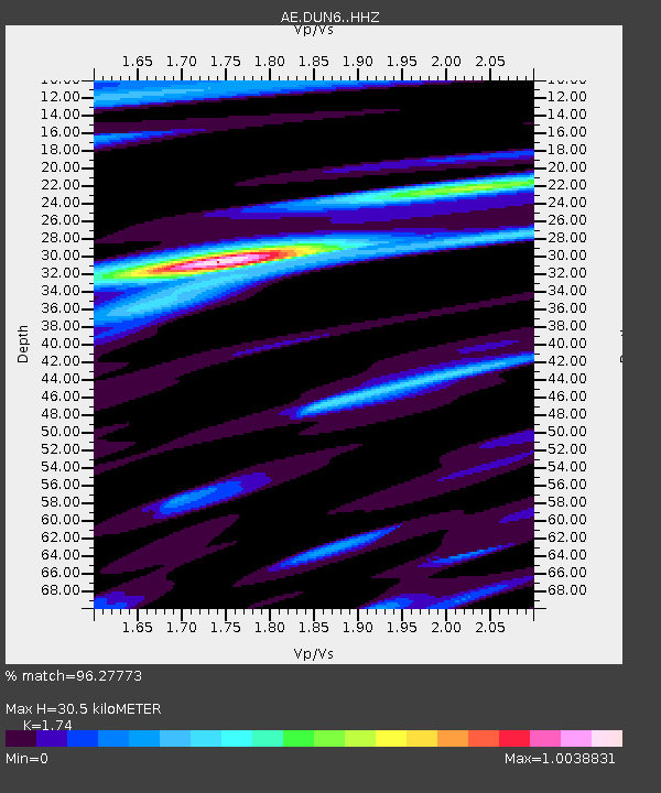
DUN6 Lazy B Ranch - Earthquake Result Viewer
| Earthquake location: |
Near East Coast Of Honshu, Japan |
| Earthquake latitude/longitude: |
38.5/141.6 |
| Earthquake time(UTC): |
2021/03/20 (079) 09:09:45 GMT |
| Earthquake Depth: |
54 km |
| Earthquake Magnitude: |
7.0 Mww |
| Earthquake Catalog/Contributor: |
NEIC PDE/us |
|
| Network: |
AE Arizona Broadband Seismic Network |
| Station: |
DUN6 Lazy B Ranch |
| Lat/Lon: |
32.55 N/109.09 W |
| Elevation: |
1259 m |
|
| Distance: |
83.5 deg |
| Az: |
53.336 deg |
| Baz: |
311.795 deg |
| Ray Param: |
0.046029374 |
| Estimated Moho Depth: |
30.5 km |
| Estimated Crust Vp/Vs: |
1.74 |
| Assumed Crust Vp: |
6.276 km/s |
| Estimated Crust Vs: |
3.607 km/s |
| Estimated Crust Poisson's Ratio: |
0.25 |
|
| Radial Match: |
96.27773 % |
| Radial Bump: |
316 |
| Transverse Match: |
91.27529 % |
| Transverse Bump: |
400 |
| SOD ConfigId: |
24334971 |
| Insert Time: |
2021-04-03 09:12:28.137 +0000 |
| GWidth: |
2.5 |
| Max Bumps: |
400 |
| Tol: |
0.001 |
|

Signal To Noise
| Channel | StoN | STA | LTA |
| AE:DUN6: :HHZ:20210320T09:21:36.299996Z | 4.5291615 | 3.1691989E-6 | 6.9973197E-7 |
| AE:DUN6: :HHN:20210320T09:21:36.299996Z | 1.4459598 | 1.1495099E-6 | 7.9498056E-7 |
| AE:DUN6: :HHE:20210320T09:21:36.299996Z | 1.0457016 | 1.1435707E-6 | 1.0935918E-6 |
| Arrivals |
| Ps | 3.7 SECOND |
| PpPs | 13 SECOND |
| PsPs/PpSs | 17 SECOND |


