You are here: Home > Network List > AG - Arkansas Seismic Network Stations List
> Station WHAR Woolly Hollow State Park,AR > Earthquake Result Viewer
WHAR Woolly Hollow State Park,AR - Earthquake Result Viewer
| Earthquake location: |
Near East Coast Of Honshu, Japan |
| Earthquake latitude/longitude: |
38.5/141.6 |
| Earthquake time(UTC): |
2021/03/20 (079) 09:09:45 GMT |
| Earthquake Depth: |
54 km |
| Earthquake Magnitude: |
7.0 Mww |
| Earthquake Catalog/Contributor: |
NEIC PDE/us |
|
| Network: |
AG Arkansas Seismic Network |
| Station: |
WHAR Woolly Hollow State Park,AR |
| Lat/Lon: |
35.29 N/92.29 W |
| Elevation: |
184 m |
|
| Distance: |
91.3 deg |
| Az: |
41.385 deg |
| Baz: |
320.631 deg |
| Ray Param: |
0.041614115 |
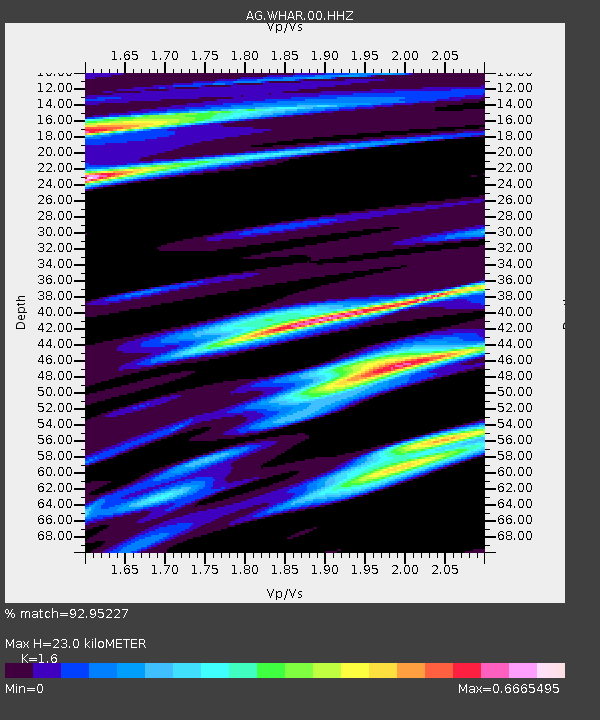
| Estimated Moho Depth: |
23.0 km |
| Estimated Crust Vp/Vs: |
1.60 |
| Assumed Crust Vp: |
6.498 km/s |
| Estimated Crust Vs: |
4.061 km/s |
| Estimated Crust Poisson's Ratio: |
0.18 |
|
| Radial Match: |
92.95227 % |
| Radial Bump: |
320 |
| Transverse Match: |
57.897377 % |
| Transverse Bump: |
396 |
| SOD ConfigId: |
24334971 |
| Insert Time: |
2021-04-03 09:12:45.907 +0000 |
| GWidth: |
2.5 |
| Max Bumps: |
400 |
| Tol: |
0.001 |
|

Signal To Noise
| Channel | StoN | STA | LTA |
| AG:WHAR:00:HHZ:20210320T09:22:13.529977Z | 4.476678 | 1.6897062E-6 | 3.7744647E-7 |
| AG:WHAR:00:HHN:20210320T09:22:13.529977Z | 1.5095178 | 5.141713E-7 | 3.4061955E-7 |
| AG:WHAR:00:HHE:20210320T09:22:13.529977Z | 1.764386 | 5.559502E-7 | 3.1509555E-7 |
| Arrivals |
| Ps | 2.2 SECOND |
| PpPs | 9.0 SECOND |
| PsPs/PpSs | 11 SECOND |


