You are here: Home > Network List > AK - Alaska Regional Network Stations List
> Station MESA Mesa, AK, USA > Earthquake Result Viewer
MESA Mesa, AK, USA - Earthquake Result Viewer
| Earthquake location: |
Near East Coast Of Honshu, Japan |
| Earthquake latitude/longitude: |
38.5/141.6 |
| Earthquake time(UTC): |
2021/03/20 (079) 09:09:45 GMT |
| Earthquake Depth: |
54 km |
| Earthquake Magnitude: |
7.0 Mww |
| Earthquake Catalog/Contributor: |
NEIC PDE/us |
|
| Network: |
AK Alaska Regional Network |
| Station: |
MESA Mesa, AK, USA |
| Lat/Lon: |
60.18 N/141.95 W |
| Elevation: |
1907 m |
|
| Distance: |
51.1 deg |
| Az: |
38.666 deg |
| Baz: |
281.146 deg |
| Ray Param: |
0.06752781 |
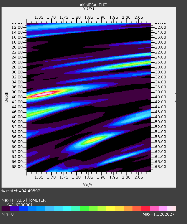
| Estimated Moho Depth: |
38.5 km |
| Estimated Crust Vp/Vs: |
1.67 |
| Assumed Crust Vp: |
6.566 km/s |
| Estimated Crust Vs: |
3.932 km/s |
| Estimated Crust Poisson's Ratio: |
0.22 |
|
| Radial Match: |
84.49592 % |
| Radial Bump: |
400 |
| Transverse Match: |
76.41979 % |
| Transverse Bump: |
400 |
| SOD ConfigId: |
24334971 |
| Insert Time: |
2021-04-03 09:14:24.774 +0000 |
| GWidth: |
2.5 |
| Max Bumps: |
400 |
| Tol: |
0.001 |
|

Signal To Noise
| Channel | StoN | STA | LTA |
| AK:MESA: :BHZ:20210320T09:18:11.527993Z | 4.003842 | 2.0266214E-6 | 5.0616916E-7 |
| AK:MESA: :BHN:20210320T09:18:11.527993Z | 2.1724305 | 1.0595405E-6 | 4.8772125E-7 |
| AK:MESA: :BHE:20210320T09:18:11.527993Z | 1.6027083 | 9.084039E-7 | 5.66793E-7 |
| Arrivals |
| Ps | 4.2 SECOND |
| PpPs | 15 SECOND |
| PsPs/PpSs | 19 SECOND |


