You are here: Home > Network List > GE - GEOFON Stations List
> Station LAST GEOFON Station Lasithi, Greece > Earthquake Result Viewer
LAST GEOFON Station Lasithi, Greece - Earthquake Result Viewer
| Earthquake location: |
Mozambique |
| Earthquake latitude/longitude: |
-21.3/33.6 |
| Earthquake time(UTC): |
2006/02/22 (053) 22:19:07 GMT |
| Earthquake Depth: |
11 km |
| Earthquake Magnitude: |
6.5 MB, 7.5 MS, 7.0 MW, 7.0 MW |
| Earthquake Catalog/Contributor: |
WHDF/NEIC |
|
| Network: |
GE GEOFON |
| Station: |
LAST GEOFON Station Lasithi, Greece |
| Lat/Lon: |
35.16 N/25.48 E |
| Elevation: |
870 m |
|
| Distance: |
56.7 deg |
| Az: |
352.056 deg |
| Baz: |
170.952 deg |
| Ray Param: |
0.06396906 |
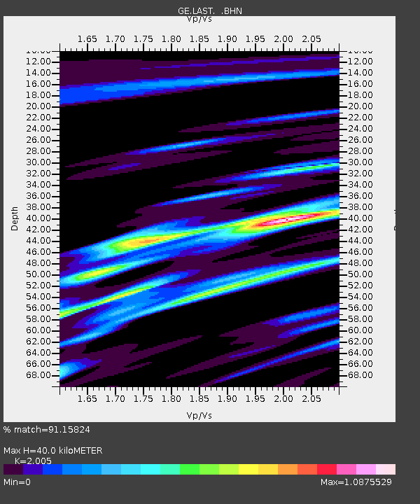
| Estimated Moho Depth: |
40.0 km |
| Estimated Crust Vp/Vs: |
2.01 |
| Assumed Crust Vp: |
5.627 km/s |
| Estimated Crust Vs: |
2.806 km/s |
| Estimated Crust Poisson's Ratio: |
0.33 |
|
| Radial Match: |
91.15824 % |
| Radial Bump: |
400 |
| Transverse Match: |
82.51973 % |
| Transverse Bump: |
400 |
| SOD ConfigId: |
2422 |
| Insert Time: |
2010-03-09 06:40:38.591 +0000 |
| GWidth: |
2.5 |
| Max Bumps: |
400 |
| Tol: |
0.001 |
|

Signal To Noise
| Channel | StoN | STA | LTA |
| GE:LAST: :BHN:20060222T22:28:20.172009Z | 10.835625 | 6.438088E-7 | 5.941593E-8 |
| GE:LAST: :BHE:20060222T22:28:20.193005Z | 2.1261563 | 1.7265944E-7 | 8.120731E-8 |
| GE:LAST: :BHZ:20060222T22:28:20.172009Z | 30.268896 | 1.4495035E-6 | 4.7887557E-8 |
| Arrivals |
| Ps | 7.4 SECOND |
| PpPs | 21 SECOND |
| PsPs/PpSs | 28 SECOND |


