You are here: Home > Network List > TX - Texas Seismological Network Stations List
> Station SN01 Snyder 1 > Earthquake Result Viewer
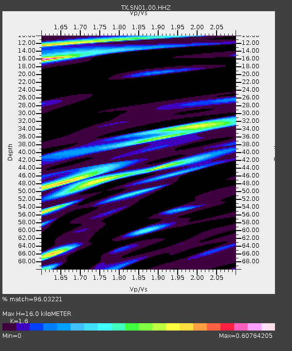
SN01 Snyder 1 - Earthquake Result Viewer
| Earthquake location: |
Tonga Islands |
| Earthquake latitude/longitude: |
-15.4/-173.2 |
| Earthquake time(UTC): |
2017/11/04 (308) 09:00:19 GMT |
| Earthquake Depth: |
10 km |
| Earthquake Magnitude: |
6.8 Mww |
| Earthquake Catalog/Contributor: |
NEIC PDE/us |
|
| Network: |
TX Texas Seismological Network |
| Station: |
SN01 Snyder 1 |
| Lat/Lon: |
32.86 N/100.89 W |
| Elevation: |
717 m |
|
| Distance: |
84.0 deg |
| Az: |
53.739 deg |
| Baz: |
247.559 deg |
| Ray Param: |
0.045780245 |
| Estimated Moho Depth: |
16.0 km |
| Estimated Crust Vp/Vs: |
1.60 |
| Assumed Crust Vp: |
6.426 km/s |
| Estimated Crust Vs: |
4.016 km/s |
| Estimated Crust Poisson's Ratio: |
0.18 |
|
| Radial Match: |
96.03221 % |
| Radial Bump: |
400 |
| Transverse Match: |
91.553986 % |
| Transverse Bump: |
400 |
| SOD ConfigId: |
2429771 |
| Insert Time: |
2017-11-18 09:07:34.934 +0000 |
| GWidth: |
2.5 |
| Max Bumps: |
400 |
| Tol: |
0.001 |
|

Signal To Noise
| Channel | StoN | STA | LTA |
| TX:SN01:00:HHZ:20171104T09:12:18.980Z | 22.622026 | 3.2566586E-6 | 1.4395962E-7 |
| TX:SN01:00:HH1:20171104T09:12:18.980Z | 2.4987764 | 3.9775736E-7 | 1.5918084E-7 |
| TX:SN01:00:HH2:20171104T09:12:18.980Z | 6.0059357 | 7.175302E-7 | 1.1947019E-7 |
| Arrivals |
| Ps | 1.5 SECOND |
| PpPs | 6.3 SECOND |
| PsPs/PpSs | 7.8 SECOND |


