You are here: Home > Network List > AK - Alaska Regional Network Stations List
> Station TABL Table Mountain, AK, USA > Earthquake Result Viewer
TABL Table Mountain, AK, USA - Earthquake Result Viewer
| Earthquake location: |
Near East Coast Of Honshu, Japan |
| Earthquake latitude/longitude: |
38.5/141.6 |
| Earthquake time(UTC): |
2021/03/20 (079) 09:09:45 GMT |
| Earthquake Depth: |
54 km |
| Earthquake Magnitude: |
7.0 Mww |
| Earthquake Catalog/Contributor: |
NEIC PDE/us |
|
| Network: |
AK Alaska Regional Network |
| Station: |
TABL Table Mountain, AK, USA |
| Lat/Lon: |
60.44 N/141.14 W |
| Elevation: |
2050 m |
|
| Distance: |
51.4 deg |
| Az: |
38.234 deg |
| Baz: |
281.574 deg |
| Ray Param: |
0.06730734 |
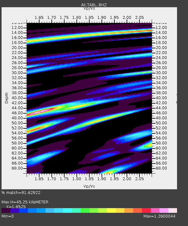
| Estimated Moho Depth: |
45.25 km |
| Estimated Crust Vp/Vs: |
1.65 |
| Assumed Crust Vp: |
6.566 km/s |
| Estimated Crust Vs: |
3.973 km/s |
| Estimated Crust Poisson's Ratio: |
0.21 |
|
| Radial Match: |
91.62922 % |
| Radial Bump: |
400 |
| Transverse Match: |
83.92804 % |
| Transverse Bump: |
400 |
| SOD ConfigId: |
24334971 |
| Insert Time: |
2021-04-03 09:15:14.777 +0000 |
| GWidth: |
2.5 |
| Max Bumps: |
400 |
| Tol: |
0.001 |
|

Signal To Noise
| Channel | StoN | STA | LTA |
| AK:TABL: :BHZ:20210320T09:18:14.068001Z | 9.735835 | 2.1725707E-6 | 2.2315196E-7 |
| AK:TABL: :BHN:20210320T09:18:14.068001Z | 0.9535522 | 4.1113108E-7 | 4.311574E-7 |
| AK:TABL: :BHE:20210320T09:18:14.068001Z | 4.146216 | 1.0361285E-6 | 2.498974E-7 |
| Arrivals |
| Ps | 4.8 SECOND |
| PpPs | 17 SECOND |
| PsPs/PpSs | 22 SECOND |


