You are here: Home > Network List > TX - Texas Seismological Network Stations List
> Station SN04 Snyder 4 > Earthquake Result Viewer
SN04 Snyder 4 - Earthquake Result Viewer
| Earthquake location: |
Tonga Islands |
| Earthquake latitude/longitude: |
-15.4/-173.2 |
| Earthquake time(UTC): |
2017/11/04 (308) 09:00:19 GMT |
| Earthquake Depth: |
10 km |
| Earthquake Magnitude: |
6.8 Mww |
| Earthquake Catalog/Contributor: |
NEIC PDE/us |
|
| Network: |
TX Texas Seismological Network |
| Station: |
SN04 Snyder 4 |
| Lat/Lon: |
32.90 N/100.87 W |
| Elevation: |
716 m |
|
| Distance: |
84.0 deg |
| Az: |
53.711 deg |
| Baz: |
247.567 deg |
| Ray Param: |
0.04575972 |
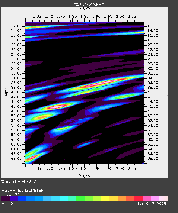
| Estimated Moho Depth: |
46.0 km |
| Estimated Crust Vp/Vs: |
1.73 |
| Assumed Crust Vp: |
6.426 km/s |
| Estimated Crust Vs: |
3.715 km/s |
| Estimated Crust Poisson's Ratio: |
0.25 |
|
| Radial Match: |
94.32177 % |
| Radial Bump: |
400 |
| Transverse Match: |
91.15 % |
| Transverse Bump: |
400 |
| SOD ConfigId: |
2429771 |
| Insert Time: |
2017-11-18 09:07:39.213 +0000 |
| GWidth: |
2.5 |
| Max Bumps: |
400 |
| Tol: |
0.001 |
|
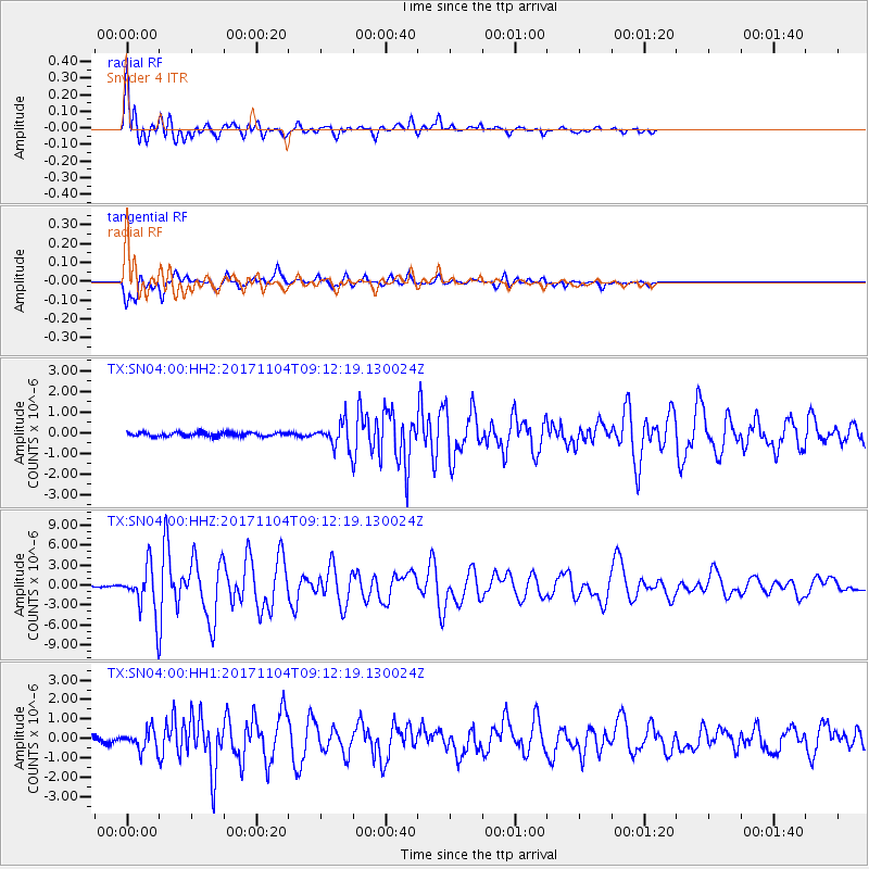
Signal To Noise
| Channel | StoN | STA | LTA |
| TX:SN04:00:HHZ:20171104T09:12:19.130024Z | 20.687037 | 3.3295062E-6 | 1.609465E-7 |
| TX:SN04:00:HH1:20171104T09:12:19.130024Z | 3.225086 | 5.0510795E-7 | 1.5661846E-7 |
| TX:SN04:00:HH2:20171104T09:12:19.130024Z | 6.409308 | 6.055411E-7 | 9.44784E-8 |
| Arrivals |
| Ps | 5.4 SECOND |
| PpPs | 19 SECOND |
| PsPs/PpSs | 24 SECOND |


