You are here: Home > Network List > AK - Alaska Regional Network Stations List
> Station PS12 TAPS Pump Station 12, AK, USA > Earthquake Result Viewer
PS12 TAPS Pump Station 12, AK, USA - Earthquake Result Viewer
| Earthquake location: |
Near East Coast Of Honshu, Japan |
| Earthquake latitude/longitude: |
38.5/141.6 |
| Earthquake time(UTC): |
2021/03/20 (079) 09:09:45 GMT |
| Earthquake Depth: |
54 km |
| Earthquake Magnitude: |
7.0 Mww |
| Earthquake Catalog/Contributor: |
NEIC PDE/us |
|
| Network: |
AK Alaska Regional Network |
| Station: |
PS12 TAPS Pump Station 12, AK, USA |
| Lat/Lon: |
61.47 N/145.15 W |
| Elevation: |
563 m |
|
| Distance: |
49.3 deg |
| Az: |
37.325 deg |
| Baz: |
277.5 deg |
| Ray Param: |
0.06866759 |
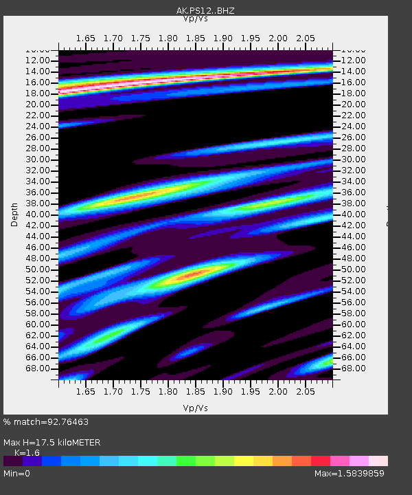
| Estimated Moho Depth: |
17.5 km |
| Estimated Crust Vp/Vs: |
1.60 |
| Assumed Crust Vp: |
6.566 km/s |
| Estimated Crust Vs: |
4.104 km/s |
| Estimated Crust Poisson's Ratio: |
0.18 |
|
| Radial Match: |
92.76463 % |
| Radial Bump: |
400 |
| Transverse Match: |
83.443344 % |
| Transverse Bump: |
400 |
| SOD ConfigId: |
24334971 |
| Insert Time: |
2021-04-03 09:15:42.968 +0000 |
| GWidth: |
2.5 |
| Max Bumps: |
400 |
| Tol: |
0.001 |
|

Signal To Noise
| Channel | StoN | STA | LTA |
| AK:PS12: :BHZ:20210320T09:17:58.268014Z | 17.586258 | 2.1173785E-6 | 1.203996E-7 |
| AK:PS12: :BHN:20210320T09:17:58.268014Z | 3.8188915 | 9.0353046E-7 | 2.3659494E-7 |
| AK:PS12: :BHE:20210320T09:17:58.268014Z | 10.72559 | 1.1706904E-6 | 1.0914928E-7 |
| Arrivals |
| Ps | 1.7 SECOND |
| PpPs | 6.5 SECOND |
| PsPs/PpSs | 8.2 SECOND |


