You are here: Home > Network List > AK - Alaska Regional Network Stations List
> Station C21K Knifeblade Ridge, AK, USA > Earthquake Result Viewer
C21K Knifeblade Ridge, AK, USA - Earthquake Result Viewer
| Earthquake location: |
Near East Coast Of Honshu, Japan |
| Earthquake latitude/longitude: |
38.5/141.6 |
| Earthquake time(UTC): |
2021/03/20 (079) 09:09:45 GMT |
| Earthquake Depth: |
54 km |
| Earthquake Magnitude: |
7.0 Mww |
| Earthquake Catalog/Contributor: |
NEIC PDE/us |
|
| Network: |
AK Alaska Regional Network |
| Station: |
C21K Knifeblade Ridge, AK, USA |
| Lat/Lon: |
69.16 N/154.78 W |
| Elevation: |
409 m |
|
| Distance: |
45.3 deg |
| Az: |
26.813 deg |
| Baz: |
261.586 deg |
| Ray Param: |
0.071222596 |
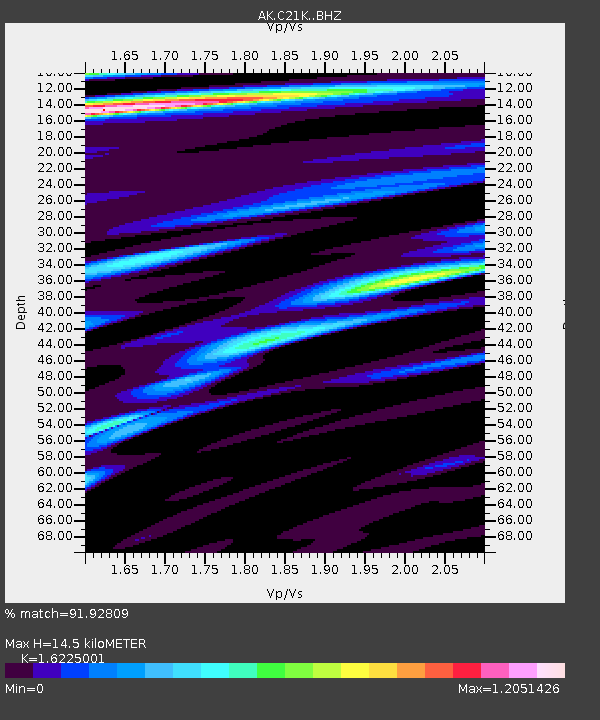
| Estimated Moho Depth: |
14.5 km |
| Estimated Crust Vp/Vs: |
1.62 |
| Assumed Crust Vp: |
6.221 km/s |
| Estimated Crust Vs: |
3.834 km/s |
| Estimated Crust Poisson's Ratio: |
0.19 |
|
| Radial Match: |
91.92809 % |
| Radial Bump: |
400 |
| Transverse Match: |
86.98092 % |
| Transverse Bump: |
400 |
| SOD ConfigId: |
24334971 |
| Insert Time: |
2021-04-03 09:15:55.970 +0000 |
| GWidth: |
2.5 |
| Max Bumps: |
400 |
| Tol: |
0.001 |
|

Signal To Noise
| Channel | StoN | STA | LTA |
| AK:C21K: :BHZ:20210320T09:17:27.22001Z | 24.183554 | 5.6395947E-6 | 2.3319959E-7 |
| AK:C21K: :BHN:20210320T09:17:27.22001Z | 1.3811257 | 3.275766E-7 | 2.3718088E-7 |
| AK:C21K: :BHE:20210320T09:17:27.22001Z | 9.666335 | 2.0816744E-6 | 2.1535301E-7 |
| Arrivals |
| Ps | 1.5 SECOND |
| PpPs | 5.7 SECOND |
| PsPs/PpSs | 7.3 SECOND |


