You are here: Home > Network List > TX - Texas Seismological Network Stations List
> Station SN06 Snyder 6 > Earthquake Result Viewer
SN06 Snyder 6 - Earthquake Result Viewer
| Earthquake location: |
Tonga Islands |
| Earthquake latitude/longitude: |
-15.4/-173.2 |
| Earthquake time(UTC): |
2017/11/04 (308) 09:00:19 GMT |
| Earthquake Depth: |
10 km |
| Earthquake Magnitude: |
6.8 Mww |
| Earthquake Catalog/Contributor: |
NEIC PDE/us |
|
| Network: |
TX Texas Seismological Network |
| Station: |
SN06 Snyder 6 |
| Lat/Lon: |
32.88 N/100.93 W |
| Elevation: |
769 m |
|
| Distance: |
84.0 deg |
| Az: |
53.71 deg |
| Baz: |
247.532 deg |
| Ray Param: |
0.045799583 |
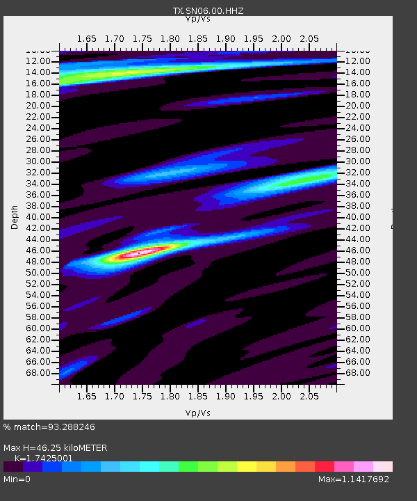
| Estimated Moho Depth: |
46.25 km |
| Estimated Crust Vp/Vs: |
1.74 |
| Assumed Crust Vp: |
6.426 km/s |
| Estimated Crust Vs: |
3.688 km/s |
| Estimated Crust Poisson's Ratio: |
0.25 |
|
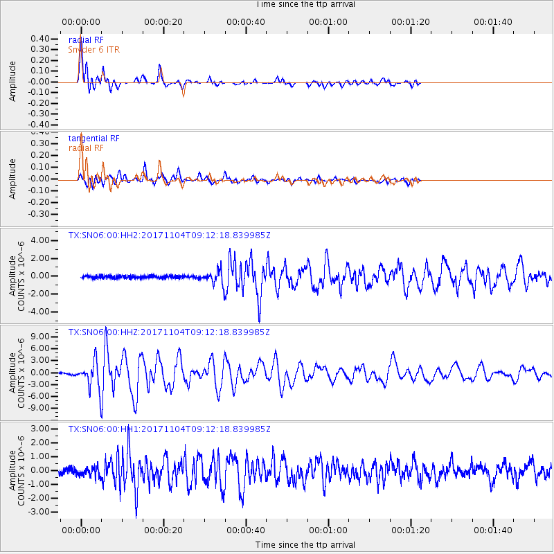
| Radial Match: |
93.288246 % |
| Radial Bump: |
400 |
| Transverse Match: |
90.02743 % |
| Transverse Bump: |
400 |
| SOD ConfigId: |
2429771 |
| Insert Time: |
2017-11-18 09:07:44.422 +0000 |
| GWidth: |
2.5 |
| Max Bumps: |
400 |
| Tol: |
0.001 |
|
Signal To Noise
| Channel | StoN | STA | LTA |
| TX:SN06:00:HHZ:20171104T09:12:18.839985Z | 18.37455 | 3.282131E-6 | 1.7862375E-7 |
| TX:SN06:00:HH1:20171104T09:12:18.839985Z | 1.4212948 | 2.9405246E-7 | 2.0689055E-7 |
| TX:SN06:00:HH2:20171104T09:12:18.839985Z | 5.2999372 | 7.748441E-7 | 1.4619873E-7 |
| Arrivals |
| Ps | 5.5 SECOND |
| PpPs | 19 SECOND |
| PsPs/PpSs | 25 SECOND |


