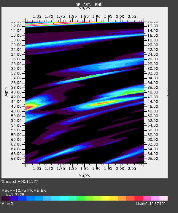
LAST GEOFON Station Lasithi, Greece - Earthquake Result Viewer

Earthquake location: Near S. Coast Of Western Honshu
Earthquake latitude/longitude: 33.1/136.6
Earthquake time(UTC): 2004/09/05 (249) 10:07:07 GMT
Earthquake Depth: 14 km
Earthquake Magnitude: 6.7 MB, 7.0 MS, 7.2 MW, 7.0 MW
Earthquake Catalog/Contributor: WHDF/NEIC
Network: GE GEOFON
Station: LAST GEOFON Station Lasithi, Greece
Lat/Lon: 35.16 N/25.48 E
Elevation: 870 m
Distance: 86.4 deg
Az: 310.027 deg
Baz: 51.697 deg
Ray Param: 0.04409031
Estimated Moho Depth: 10.75 km
Estimated Crust Vp/Vs: 1.72
Assumed Crust Vp: 5.627 km/s
Estimated Crust Vs: 3.276 km/s
Estimated Crust Poisson's Ratio: 0.24
Radial Match: 90.11177 %
Radial Bump: 354
Transverse Match: 88.72349 %
Transverse Bump: 400
SOD ConfigId: 2459
Insert Time: 2010-03-09 06:41:13.136 +0000
GWidth: 2.5
Max Bumps: 400
Tol: 0.001

Signal To Noise

ChannelStoNSTALTA
GE:LAST: :BHN:20040905T10:19:17.989006Z15.1971574.3070395E-62.8341088E-7
GE:LAST: :BHE:20040905T10:19:17.949028Z5.01973721.7255478E-63.437526E-7
GE:LAST: :BHZ:20040905T10:19:17.97802Z38.32081.09191E-52.8493923E-7
Arrivals
Ps1.4 SECOND
PpPs5.1 SECOND
PsPs/PpSs6.5 SECOND