You are here: Home > Network List > AU - Australian Seismological Centre Stations List
> Station MORW Morawa, Western Australia > Earthquake Result Viewer
MORW Morawa, Western Australia - Earthquake Result Viewer
| Earthquake location: |
Near East Coast Of Honshu, Japan |
| Earthquake latitude/longitude: |
38.5/141.6 |
| Earthquake time(UTC): |
2021/03/20 (079) 09:09:45 GMT |
| Earthquake Depth: |
54 km |
| Earthquake Magnitude: |
7.0 Mww |
| Earthquake Catalog/Contributor: |
NEIC PDE/us |
|
| Network: |
AU Australian Seismological Centre |
| Station: |
MORW Morawa, Western Australia |
| Lat/Lon: |
29.07 S/116.04 E |
| Elevation: |
296 m |
|
| Distance: |
71.3 deg |
| Az: |
203.504 deg |
| Baz: |
20.952 deg |
| Ray Param: |
0.054308847 |
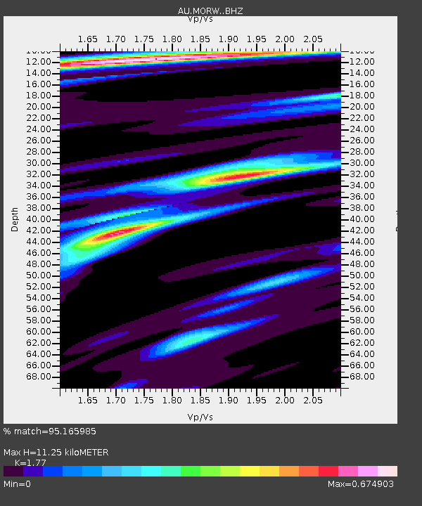
| Estimated Moho Depth: |
11.25 km |
| Estimated Crust Vp/Vs: |
1.77 |
| Assumed Crust Vp: |
6.459 km/s |
| Estimated Crust Vs: |
3.649 km/s |
| Estimated Crust Poisson's Ratio: |
0.27 |
|
| Radial Match: |
95.165985 % |
| Radial Bump: |
281 |
| Transverse Match: |
81.0494 % |
| Transverse Bump: |
400 |
| SOD ConfigId: |
24334971 |
| Insert Time: |
2021-04-03 09:17:10.109 +0000 |
| GWidth: |
2.5 |
| Max Bumps: |
400 |
| Tol: |
0.001 |
|

Signal To Noise
| Channel | StoN | STA | LTA |
| AU:MORW: :BHZ:20210320T09:20:28.344002Z | 14.431226 | 4.557341E-6 | 3.1579722E-7 |
| AU:MORW: :BHN:20210320T09:20:28.344002Z | 6.8995094 | 1.894426E-6 | 2.74574E-7 |
| AU:MORW: :BHE:20210320T09:20:28.344002Z | 3.4140735 | 8.2038594E-7 | 2.4029535E-7 |
| Arrivals |
| Ps | 1.4 SECOND |
| PpPs | 4.7 SECOND |
| PsPs/PpSs | 6.0 SECOND |


