You are here: Home > Network List > GE - GEOFON Stations List
> Station LAST GEOFON Station Lasithi, Greece > Earthquake Result Viewer
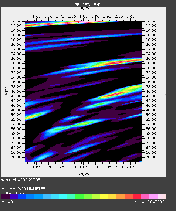
LAST GEOFON Station Lasithi, Greece - Earthquake Result Viewer
| Earthquake location: |
Kuril Islands |
| Earthquake latitude/longitude: |
47.2/151.3 |
| Earthquake time(UTC): |
2004/07/08 (190) 10:30:49 GMT |
| Earthquake Depth: |
128 km |
| Earthquake Magnitude: |
5.9 MB, 6.4 MW, 6.3 MW |
| Earthquake Catalog/Contributor: |
WHDF/NEIC |
|
| Network: |
GE GEOFON |
| Station: |
LAST GEOFON Station Lasithi, Greece |
| Lat/Lon: |
35.16 N/25.48 E |
| Elevation: |
870 m |
|
| Distance: |
84.7 deg |
| Az: |
318.149 deg |
| Baz: |
33.73 deg |
| Ray Param: |
0.045002602 |
| Estimated Moho Depth: |
10.25 km |
| Estimated Crust Vp/Vs: |
1.83 |
| Assumed Crust Vp: |
5.627 km/s |
| Estimated Crust Vs: |
3.079 km/s |
| Estimated Crust Poisson's Ratio: |
0.29 |
|
| Radial Match: |
83.121735 % |
| Radial Bump: |
400 |
| Transverse Match: |
84.05964 % |
| Transverse Bump: |
400 |
| SOD ConfigId: |
2459 |
| Insert Time: |
2010-03-09 06:41:18.062 +0000 |
| GWidth: |
2.5 |
| Max Bumps: |
400 |
| Tol: |
0.001 |
|

Signal To Noise
| Channel | StoN | STA | LTA |
| GE:LAST: :BHN:20040708T10:42:37.539028Z | 10.546216 | 2.9844673E-6 | 2.829894E-7 |
| GE:LAST: :BHE:20040708T10:42:37.548Z | 1.7761924 | 9.0181044E-7 | 5.0772115E-7 |
| GE:LAST: :BHZ:20040708T10:42:37.539028Z | 23.822622 | 6.6107364E-6 | 2.7749826E-7 |
| Arrivals |
| Ps | 1.5 SECOND |
| PpPs | 5.1 SECOND |
| PsPs/PpSs | 6.6 SECOND |


