You are here: Home > Network List > AZ - ANZA Regional Network Stations List
> Station LVA2 AZ.LVA2 > Earthquake Result Viewer
LVA2 AZ.LVA2 - Earthquake Result Viewer

| Earthquake location: |
Near East Coast Of Honshu, Japan |
| Earthquake latitude/longitude: |
38.5/141.6 |
| Earthquake time(UTC): |
2021/03/20 (079) 09:09:45 GMT |
| Earthquake Depth: |
54 km |
| Earthquake Magnitude: |
7.0 Mww |
| Earthquake Catalog/Contributor: |
NEIC PDE/us |
|
| Network: |
AZ ANZA Regional Network |
| Station: |
LVA2 AZ.LVA2 |
| Lat/Lon: |
33.35 N/116.56 W |
| Elevation: |
1435 m |
|
| Distance: |
78.2 deg |
| Az: |
56.812 deg |
| Baz: |
308.299 deg |
| Ray Param: |
0.04970198 |
| Estimated Moho Depth: |
31.25 km |
| Estimated Crust Vp/Vs: |
1.60 |
| Assumed Crust Vp: |
6.264 km/s |
| Estimated Crust Vs: |
3.915 km/s |
| Estimated Crust Poisson's Ratio: |
0.18 |
|
| Radial Match: |
89.828835 % |
| Radial Bump: |
400 |
| Transverse Match: |
81.87985 % |
| Transverse Bump: |
400 |
| SOD ConfigId: |
24334971 |
| Insert Time: |
2021-04-03 09:18:58.385 +0000 |
| GWidth: |
2.5 |
| Max Bumps: |
400 |
| Tol: |
0.001 |
|
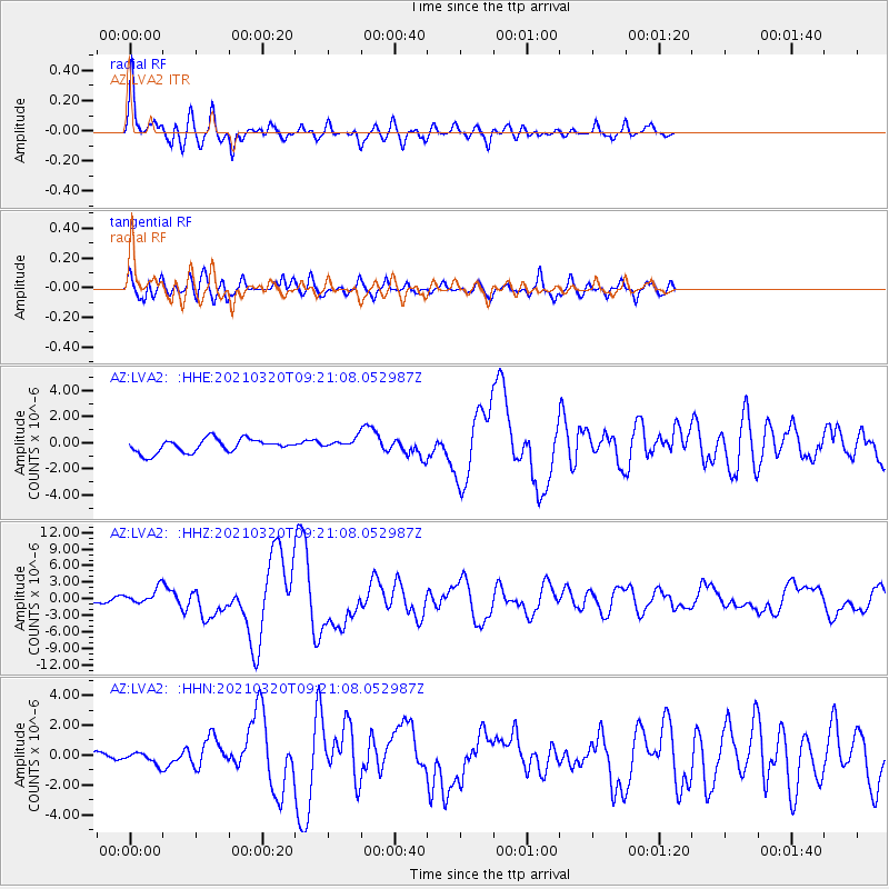
Signal To Noise
| Channel | StoN | STA | LTA |
| AZ:LVA2: :HHZ:20210320T09:21:08.052987Z | 3.0584657 | 1.367753E-6 | 4.4720235E-7 |
| AZ:LVA2: :HHN:20210320T09:21:08.052987Z | 1.1040647 | 3.7547463E-7 | 3.4008391E-7 |
| AZ:LVA2: :HHE:20210320T09:21:08.052987Z | 0.777853 | 3.9958408E-7 | 5.137013E-7 |
| Arrivals |
| Ps | 3.1 SECOND |
| PpPs | 13 SECOND |
| PsPs/PpSs | 16 SECOND |


