You are here: Home > Network List > GE - GEOFON Stations List
> Station LAST GEOFON Station Lasithi, Greece > Earthquake Result Viewer
LAST GEOFON Station Lasithi, Greece - Earthquake Result Viewer
| Earthquake location: |
Kyushu, Japan |
| Earthquake latitude/longitude: |
31.0/130.0 |
| Earthquake time(UTC): |
2005/11/21 (325) 15:36:30 GMT |
| Earthquake Depth: |
145 km |
| Earthquake Magnitude: |
5.9 MB, 6.2 MW, 6.2 MW |
| Earthquake Catalog/Contributor: |
WHDF/NEIC |
|
| Network: |
GE GEOFON |
| Station: |
LAST GEOFON Station Lasithi, Greece |
| Lat/Lon: |
35.16 N/25.48 E |
| Elevation: |
870 m |
|
| Distance: |
83.2 deg |
| Az: |
306.991 deg |
| Baz: |
56.816 deg |
| Ray Param: |
0.045987997 |
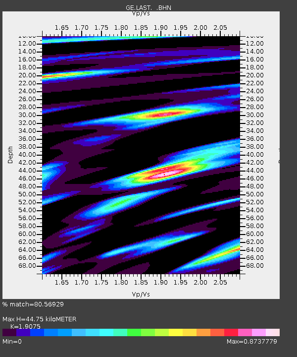
| Estimated Moho Depth: |
44.75 km |
| Estimated Crust Vp/Vs: |
1.91 |
| Assumed Crust Vp: |
5.627 km/s |
| Estimated Crust Vs: |
2.95 km/s |
| Estimated Crust Poisson's Ratio: |
0.31 |
|
| Radial Match: |
80.56929 % |
| Radial Bump: |
400 |
| Transverse Match: |
71.882034 % |
| Transverse Bump: |
400 |
| SOD ConfigId: |
2448 |
| Insert Time: |
2010-03-09 06:41:39.850 +0000 |
| GWidth: |
2.5 |
| Max Bumps: |
400 |
| Tol: |
0.001 |
|

Signal To Noise
| Channel | StoN | STA | LTA |
| GE:LAST: :BHN:20051121T15:48:10.102009Z | 4.5763984 | 2.6638925E-6 | 5.8209366E-7 |
| GE:LAST: :BHE:20051121T15:48:10.133015Z | 2.5560024 | 1.2896716E-6 | 5.045659E-7 |
| GE:LAST: :BHZ:20051121T15:48:10.133015Z | 11.534514 | 7.072945E-6 | 6.131984E-7 |
| Arrivals |
| Ps | 7.3 SECOND |
| PpPs | 23 SECOND |
| PsPs/PpSs | 30 SECOND |


