You are here: Home > Network List > CC - Cascade Chain Volcano Monitoring Stations List
> Station OBSR Observation Rock, Mt. Rainier, WA > Earthquake Result Viewer
OBSR Observation Rock, Mt. Rainier, WA - Earthquake Result Viewer
| Earthquake location: |
Near East Coast Of Honshu, Japan |
| Earthquake latitude/longitude: |
38.5/141.6 |
| Earthquake time(UTC): |
2021/03/20 (079) 09:09:45 GMT |
| Earthquake Depth: |
54 km |
| Earthquake Magnitude: |
7.0 Mww |
| Earthquake Catalog/Contributor: |
NEIC PDE/us |
|
| Network: |
CC Cascade Chain Volcano Monitoring |
| Station: |
OBSR Observation Rock, Mt. Rainier, WA |
| Lat/Lon: |
46.90 N/121.82 W |
| Elevation: |
2382 m |
|
| Distance: |
67.1 deg |
| Az: |
47.694 deg |
| Baz: |
302.163 deg |
| Ray Param: |
0.057080146 |
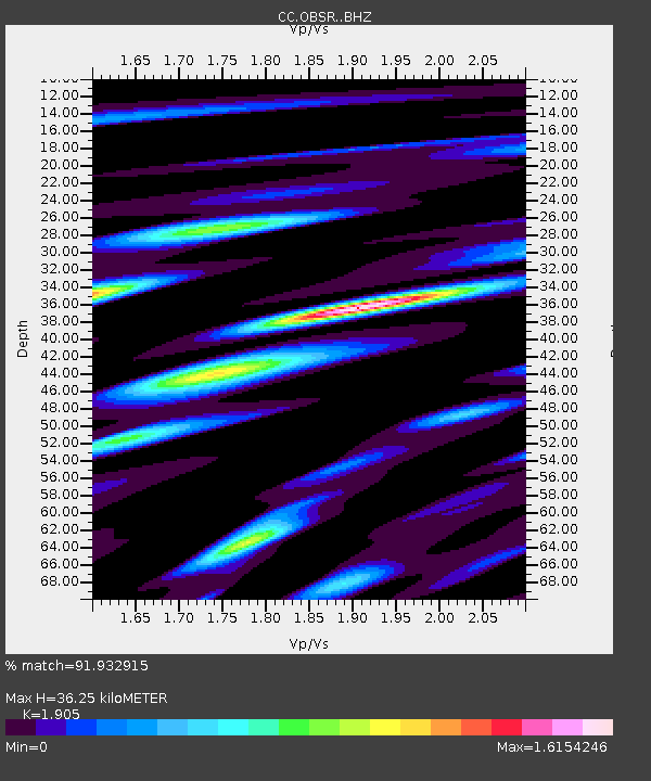
| Estimated Moho Depth: |
36.25 km |
| Estimated Crust Vp/Vs: |
1.90 |
| Assumed Crust Vp: |
6.597 km/s |
| Estimated Crust Vs: |
3.463 km/s |
| Estimated Crust Poisson's Ratio: |
0.31 |
|
| Radial Match: |
91.932915 % |
| Radial Bump: |
400 |
| Transverse Match: |
84.57079 % |
| Transverse Bump: |
400 |
| SOD ConfigId: |
24334971 |
| Insert Time: |
2021-04-03 09:20:34.666 +0000 |
| GWidth: |
2.5 |
| Max Bumps: |
400 |
| Tol: |
0.001 |
|

Signal To Noise
| Channel | StoN | STA | LTA |
| CC:OBSR: :BHZ:20210320T09:20:02.245003Z | 5.9459515 | 1.4383036E-6 | 2.418963E-7 |
| CC:OBSR: :BHN:20210320T09:20:02.245003Z | 1.8488005 | 7.249894E-7 | 3.9214038E-7 |
| CC:OBSR: :BHE:20210320T09:20:02.245003Z | 1.2026346 | 7.4496126E-7 | 6.194411E-7 |
| Arrivals |
| Ps | 5.2 SECOND |
| PpPs | 15 SECOND |
| PsPs/PpSs | 21 SECOND |


