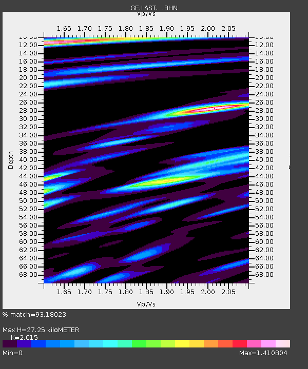
LAST GEOFON Station Lasithi, Greece - Earthquake Result Viewer

Earthquake location: Near East Coast Of Honshu, Japan
Earthquake latitude/longitude: 38.3/142.0
Earthquake time(UTC): 2005/08/16 (228) 02:46:28 GMT
Earthquake Depth: 36 km
Earthquake Magnitude: 6.5 MB, 6.8 MS, 7.2 MW, 7.1 MW
Earthquake Catalog/Contributor: WHDF/NEIC
Network: GE GEOFON
Station: LAST GEOFON Station Lasithi, Greece
Lat/Lon: 35.16 N/25.48 E
Elevation: 870 m
Distance: 86.3 deg
Az: 312.739 deg
Baz: 44.87 deg
Ray Param: 0.044133108
Estimated Moho Depth: 27.25 km
Estimated Crust Vp/Vs: 2.02
Assumed Crust Vp: 5.627 km/s
Estimated Crust Vs: 2.792 km/s
Estimated Crust Poisson's Ratio: 0.34
Radial Match: 93.18023 %
Radial Bump: 400
Transverse Match: 92.453285 %
Transverse Bump: 400
SOD ConfigId: 2475
Insert Time: 2010-03-09 06:41:53.280 +0000
GWidth: 2.5
Max Bumps: 400
Tol: 0.001

Signal To Noise

ChannelStoNSTALTA
GE:LAST: :BHN:20050816T02:58:35.152014Z37.3818554.4080803E-61.1792032E-7
GE:LAST: :BHE:20050816T02:58:35.131995Z12.838211.3512133E-61.05249356E-7
GE:LAST: :BHZ:20050816T02:58:35.131995Z94.809311.0161846E-51.0718195E-7
Arrivals
Ps5.0 SECOND
PpPs14 SECOND
PsPs/PpSs19 SECOND