You are here: Home > Network List > GE - GEOFON Stations List
> Station LAST GEOFON Station Lasithi, Greece > Earthquake Result Viewer
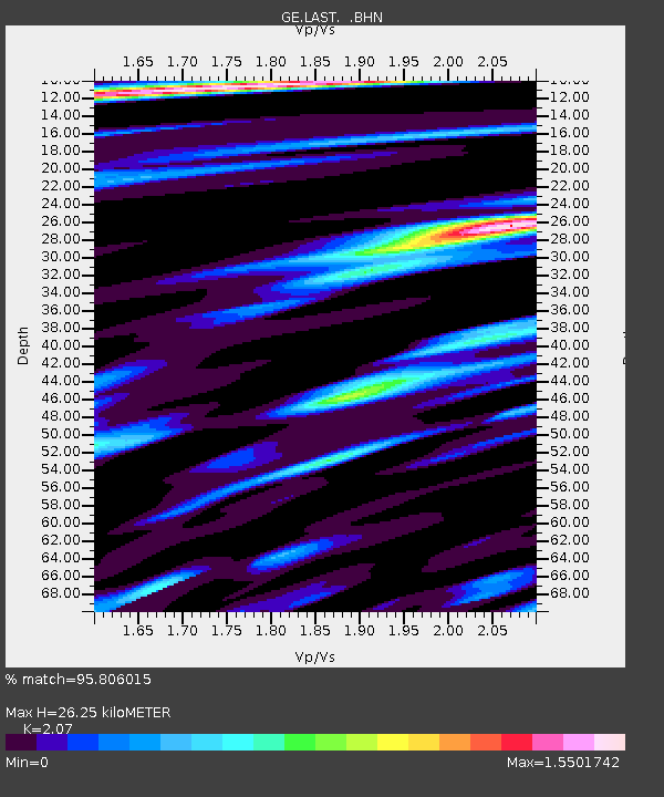
LAST GEOFON Station Lasithi, Greece - Earthquake Result Viewer
| Earthquake location: |
Kuril Islands |
| Earthquake latitude/longitude: |
43.9/146.1 |
| Earthquake time(UTC): |
2005/09/21 (264) 02:25:08 GMT |
| Earthquake Depth: |
103 km |
| Earthquake Magnitude: |
6.0 MB, 6.1 MW, 6.0 MW |
| Earthquake Catalog/Contributor: |
WHDF/NEIC |
|
| Network: |
GE GEOFON |
| Station: |
LAST GEOFON Station Lasithi, Greece |
| Lat/Lon: |
35.16 N/25.48 E |
| Elevation: |
870 m |
|
| Distance: |
84.6 deg |
| Az: |
314.936 deg |
| Baz: |
38.655 deg |
| Ray Param: |
0.045136917 |
| Estimated Moho Depth: |
26.25 km |
| Estimated Crust Vp/Vs: |
2.07 |
| Assumed Crust Vp: |
5.627 km/s |
| Estimated Crust Vs: |
2.718 km/s |
| Estimated Crust Poisson's Ratio: |
0.35 |
|
| Radial Match: |
95.806015 % |
| Radial Bump: |
400 |
| Transverse Match: |
94.58468 % |
| Transverse Bump: |
400 |
| SOD ConfigId: |
2475 |
| Insert Time: |
2010-03-09 06:41:54.666 +0000 |
| GWidth: |
2.5 |
| Max Bumps: |
400 |
| Tol: |
0.001 |
|

Signal To Noise
| Channel | StoN | STA | LTA |
| GE:LAST: :BHN:20050921T02:36:58.972Z | 20.890139 | 2.3497196E-6 | 1.12479846E-7 |
| GE:LAST: :BHE:20050921T02:36:58.963027Z | 4.418328 | 4.909578E-7 | 1.1111847E-7 |
| GE:LAST: :BHZ:20050921T02:36:58.982009Z | 62.17966 | 5.029753E-6 | 8.089065E-8 |
| Arrivals |
| Ps | 5.1 SECOND |
| PpPs | 14 SECOND |
| PsPs/PpSs | 19 SECOND |


