You are here: Home > Network List > GE - GEOFON Stations List
> Station LAST GEOFON Station Lasithi, Greece > Earthquake Result Viewer
LAST GEOFON Station Lasithi, Greece - Earthquake Result Viewer
| Earthquake location: |
Myanmar-India Border Region |
| Earthquake latitude/longitude: |
24.6/94.8 |
| Earthquake time(UTC): |
2005/09/18 (261) 07:25:59 GMT |
| Earthquake Depth: |
84 km |
| Earthquake Magnitude: |
5.6 MB, 5.7 MW, 5.7 MW |
| Earthquake Catalog/Contributor: |
WHDF/NEIC |
|
| Network: |
GE GEOFON |
| Station: |
LAST GEOFON Station Lasithi, Greece |
| Lat/Lon: |
35.16 N/25.48 E |
| Elevation: |
870 m |
|
| Distance: |
60.0 deg |
| Az: |
297.695 deg |
| Baz: |
79.74 deg |
| Ray Param: |
0.06161895 |
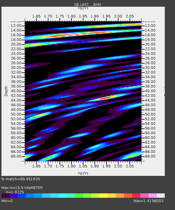
| Estimated Moho Depth: |
15.5 km |
| Estimated Crust Vp/Vs: |
1.82 |
| Assumed Crust Vp: |
5.627 km/s |
| Estimated Crust Vs: |
3.087 km/s |
| Estimated Crust Poisson's Ratio: |
0.28 |
|
| Radial Match: |
88.451935 % |
| Radial Bump: |
400 |
| Transverse Match: |
80.03329 % |
| Transverse Bump: |
400 |
| SOD ConfigId: |
2500 |
| Insert Time: |
2010-03-09 06:41:58.763 +0000 |
| GWidth: |
2.5 |
| Max Bumps: |
400 |
| Tol: |
0.001 |
|

Signal To Noise
| Channel | StoN | STA | LTA |
| GE:LAST: :BHN:20050918T07:35:26.272012Z | 3.9797342 | 3.2120275E-7 | 8.07096E-8 |
| GE:LAST: :BHE:20050918T07:35:26.262002Z | 3.2046137 | 2.9886107E-7 | 9.325962E-8 |
| GE:LAST: :BHZ:20050918T07:35:26.282021Z | 7.706664 | 6.4145365E-7 | 8.323364E-8 |
| Arrivals |
| Ps | 2.3 SECOND |
| PpPs | 7.5 SECOND |
| PsPs/PpSs | 9.9 SECOND |


