You are here: Home > Network List > CI - Caltech Regional Seismic Network Stations List
> Station SWS Sam W. Stewart, Westmorland, CA, USA > Earthquake Result Viewer
SWS Sam W. Stewart, Westmorland, CA, USA - Earthquake Result Viewer
| Earthquake location: |
Near East Coast Of Honshu, Japan |
| Earthquake latitude/longitude: |
38.5/141.6 |
| Earthquake time(UTC): |
2021/03/20 (079) 09:09:45 GMT |
| Earthquake Depth: |
54 km |
| Earthquake Magnitude: |
7.0 Mww |
| Earthquake Catalog/Contributor: |
NEIC PDE/us |
|
| Network: |
CI Caltech Regional Seismic Network |
| Station: |
SWS Sam W. Stewart, Westmorland, CA, USA |
| Lat/Lon: |
32.94 N/115.80 W |
| Elevation: |
140 m |
|
| Distance: |
79.0 deg |
| Az: |
56.731 deg |
| Baz: |
308.699 deg |
| Ray Param: |
0.049187735 |
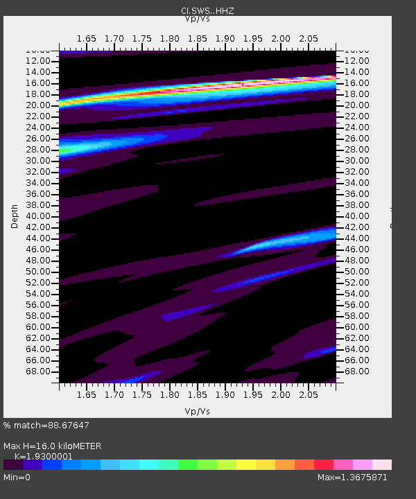
| Estimated Moho Depth: |
16.0 km |
| Estimated Crust Vp/Vs: |
1.93 |
| Assumed Crust Vp: |
6.155 km/s |
| Estimated Crust Vs: |
3.189 km/s |
| Estimated Crust Poisson's Ratio: |
0.32 |
|
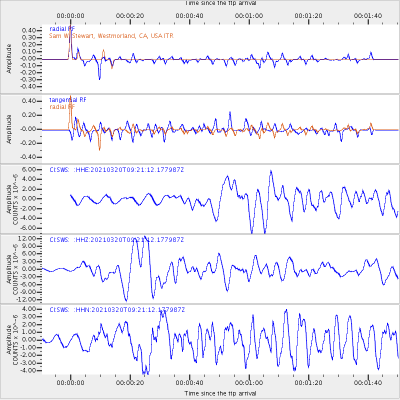
| Radial Match: |
88.67647 % |
| Radial Bump: |
307 |
| Transverse Match: |
74.55722 % |
| Transverse Bump: |
400 |
| SOD ConfigId: |
24334971 |
| Insert Time: |
2021-04-03 09:22:54.598 +0000 |
| GWidth: |
2.5 |
| Max Bumps: |
400 |
| Tol: |
0.001 |
|
Signal To Noise
| Channel | StoN | STA | LTA |
| CI:SWS: :HHZ:20210320T09:21:12.177987Z | 3.2478542 | 1.5556387E-6 | 4.789743E-7 |
| CI:SWS: :HHN:20210320T09:21:12.177987Z | 2.8068027 | 7.4565895E-7 | 2.6566133E-7 |
| CI:SWS: :HHE:20210320T09:21:12.177987Z | 1.3205441 | 7.583532E-7 | 5.742733E-7 |
| Arrivals |
| Ps | 2.5 SECOND |
| PpPs | 7.4 SECOND |
| PsPs/PpSs | 9.9 SECOND |


