You are here: Home > Network List > CN - Canadian National Seismograph Network Stations List
> Station GDR Gold River, BC, CA > Earthquake Result Viewer
GDR Gold River, BC, CA - Earthquake Result Viewer
| Earthquake location: |
Near East Coast Of Honshu, Japan |
| Earthquake latitude/longitude: |
38.5/141.6 |
| Earthquake time(UTC): |
2021/03/20 (079) 09:09:45 GMT |
| Earthquake Depth: |
54 km |
| Earthquake Magnitude: |
7.0 Mww |
| Earthquake Catalog/Contributor: |
NEIC PDE/us |
|
| Network: |
CN Canadian National Seismograph Network |
| Station: |
GDR Gold River, BC, CA |
| Lat/Lon: |
49.78 N/126.06 W |
| Elevation: |
123 m |
|
| Distance: |
63.2 deg |
| Az: |
46.529 deg |
| Baz: |
298.512 deg |
| Ray Param: |
0.05962361 |
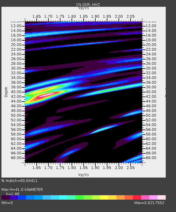
| Estimated Moho Depth: |
41.0 km |
| Estimated Crust Vp/Vs: |
1.69 |
| Assumed Crust Vp: |
6.24 km/s |
| Estimated Crust Vs: |
3.692 km/s |
| Estimated Crust Poisson's Ratio: |
0.23 |
|
| Radial Match: |
80.84411 % |
| Radial Bump: |
400 |
| Transverse Match: |
72.44695 % |
| Transverse Bump: |
400 |
| SOD ConfigId: |
24334971 |
| Insert Time: |
2021-04-03 09:23:55.896 +0000 |
| GWidth: |
2.5 |
| Max Bumps: |
400 |
| Tol: |
0.001 |
|

Signal To Noise
| Channel | StoN | STA | LTA |
| CN:GDR: :HHZ:20210320T09:19:37.039986Z | 1.7495177 | 1.3614066E-6 | 7.7816105E-7 |
| CN:GDR: :HHN:20210320T09:19:37.039986Z | 0.7887287 | 3.8542504E-7 | 4.886662E-7 |
| CN:GDR: :HHE:20210320T09:19:37.039986Z | 2.7519476 | 1.4660433E-6 | 5.3272936E-7 |
| Arrivals |
| Ps | 4.7 SECOND |
| PpPs | 17 SECOND |
| PsPs/PpSs | 22 SECOND |


