You are here: Home > Network List > CN - Canadian National Seismograph Network Stations List
> Station SYMB Survey Mountain, BC, CA > Earthquake Result Viewer
SYMB Survey Mountain, BC, CA - Earthquake Result Viewer
| Earthquake location: |
Near East Coast Of Honshu, Japan |
| Earthquake latitude/longitude: |
38.5/141.6 |
| Earthquake time(UTC): |
2021/03/20 (079) 09:09:45 GMT |
| Earthquake Depth: |
54 km |
| Earthquake Magnitude: |
7.0 Mww |
| Earthquake Catalog/Contributor: |
NEIC PDE/us |
|
| Network: |
CN Canadian National Seismograph Network |
| Station: |
SYMB Survey Mountain, BC, CA |
| Lat/Lon: |
48.56 N/123.80 W |
| Elevation: |
945 m |
|
| Distance: |
65.1 deg |
| Az: |
46.902 deg |
| Baz: |
300.378 deg |
| Ray Param: |
0.058391705 |
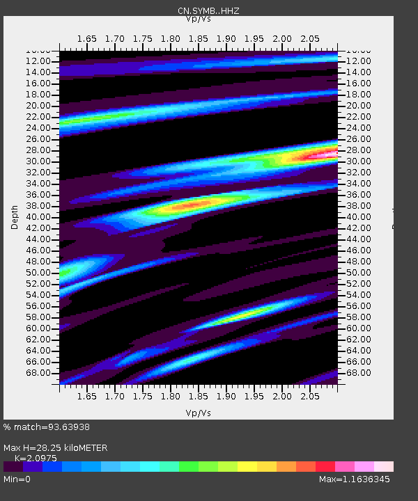
| Estimated Moho Depth: |
28.25 km |
| Estimated Crust Vp/Vs: |
2.10 |
| Assumed Crust Vp: |
6.566 km/s |
| Estimated Crust Vs: |
3.13 km/s |
| Estimated Crust Poisson's Ratio: |
0.35 |
|
| Radial Match: |
93.63938 % |
| Radial Bump: |
331 |
| Transverse Match: |
80.70882 % |
| Transverse Bump: |
400 |
| SOD ConfigId: |
24334971 |
| Insert Time: |
2021-04-03 09:25:02.521 +0000 |
| GWidth: |
2.5 |
| Max Bumps: |
400 |
| Tol: |
0.001 |
|

Signal To Noise
| Channel | StoN | STA | LTA |
| CN:SYMB: :HHZ:20210320T09:19:49.399972Z | 2.4168918 | 1.7568701E-6 | 7.26913E-7 |
| CN:SYMB: :HHN:20210320T09:19:49.399972Z | 0.4683265 | 2.5668592E-7 | 5.480918E-7 |
| CN:SYMB: :HHE:20210320T09:19:49.399972Z | 1.2152715 | 6.971894E-7 | 5.736903E-7 |
| Arrivals |
| Ps | 4.9 SECOND |
| PpPs | 13 SECOND |
| PsPs/PpSs | 18 SECOND |


