You are here: Home > Network List > US - United States National Seismic Network Stations List
> Station ELK Elko, Nevada, USA > Earthquake Result Viewer
ELK Elko, Nevada, USA - Earthquake Result Viewer
| Earthquake location: |
Tonga Islands |
| Earthquake latitude/longitude: |
-15.4/-173.2 |
| Earthquake time(UTC): |
2017/11/04 (308) 09:00:19 GMT |
| Earthquake Depth: |
10 km |
| Earthquake Magnitude: |
6.8 Mww |
| Earthquake Catalog/Contributor: |
NEIC PDE/us |
|
| Network: |
US United States National Seismic Network |
| Station: |
ELK Elko, Nevada, USA |
| Lat/Lon: |
40.74 N/115.24 W |
| Elevation: |
2210 m |
|
| Distance: |
77.4 deg |
| Az: |
41.3 deg |
| Baz: |
236.934 deg |
| Ray Param: |
0.050324015 |
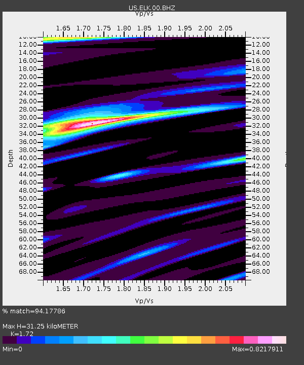
| Estimated Moho Depth: |
31.25 km |
| Estimated Crust Vp/Vs: |
1.72 |
| Assumed Crust Vp: |
6.276 km/s |
| Estimated Crust Vs: |
3.649 km/s |
| Estimated Crust Poisson's Ratio: |
0.24 |
|
| Radial Match: |
94.17786 % |
| Radial Bump: |
297 |
| Transverse Match: |
88.57814 % |
| Transverse Bump: |
396 |
| SOD ConfigId: |
2429771 |
| Insert Time: |
2017-11-18 09:08:48.897 +0000 |
| GWidth: |
2.5 |
| Max Bumps: |
400 |
| Tol: |
0.001 |
|
Signal To Noise
| Channel | StoN | STA | LTA |
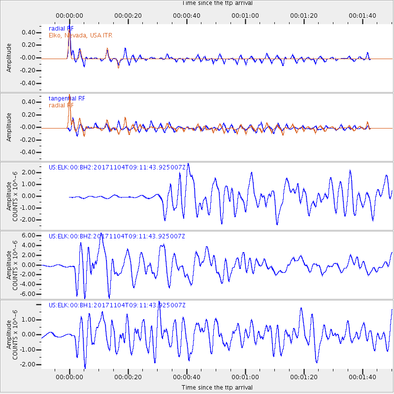
| US:ELK:00:BHZ:20171104T09:11:43.925007Z | 22.248407 | 2.623087E-6 | 1.179E-7 |
| US:ELK:00:BH1:20171104T09:11:43.925007Z | 6.3065124 | 6.415599E-7 | 1.01729746E-7 |
| US:ELK:00:BH2:20171104T09:11:43.925007Z | 12.07359 | 8.243825E-7 | 6.827981E-8 |
| Arrivals |
| Ps | 3.7 SECOND |
| PpPs | 13 SECOND |
| PsPs/PpSs | 17 SECOND |


