You are here: Home > Network List > EI - Irish National Seismic Network (INSN) Stations List
> Station IDGL INCH ISLAND, CO DONEGAL, IRELAND > Earthquake Result Viewer
IDGL INCH ISLAND, CO DONEGAL, IRELAND - Earthquake Result Viewer
| Earthquake location: |
Near East Coast Of Honshu, Japan |
| Earthquake latitude/longitude: |
38.5/141.6 |
| Earthquake time(UTC): |
2021/03/20 (079) 09:09:45 GMT |
| Earthquake Depth: |
54 km |
| Earthquake Magnitude: |
7.0 Mww |
| Earthquake Catalog/Contributor: |
NEIC PDE/us |
|
| Network: |
EI Irish National Seismic Network (INSN) |
| Station: |
IDGL INCH ISLAND, CO DONEGAL, IRELAND |
| Lat/Lon: |
55.07 N/7.51 W |
| Elevation: |
123 m |
|
| Distance: |
83.1 deg |
| Az: |
342.703 deg |
| Baz: |
23.941 deg |
| Ray Param: |
0.04630632 |
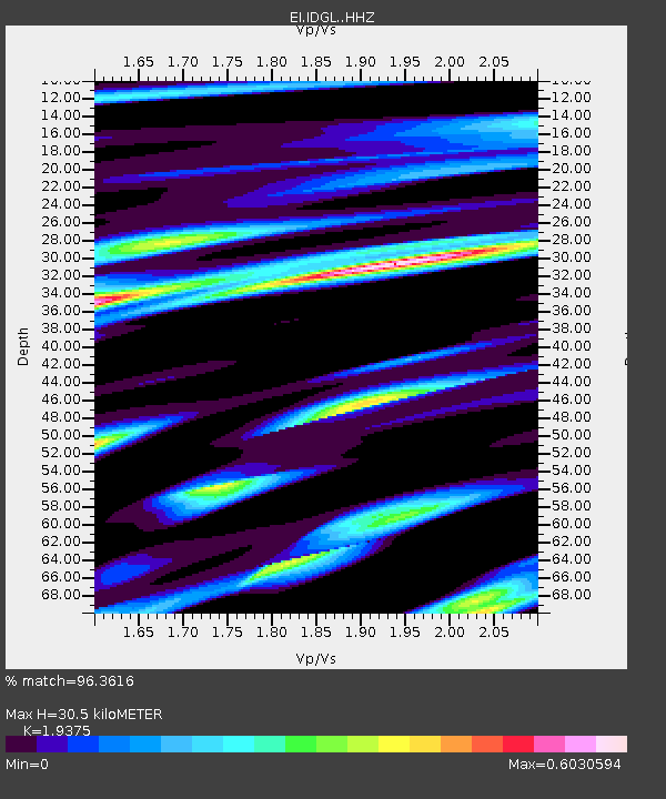
| Estimated Moho Depth: |
30.5 km |
| Estimated Crust Vp/Vs: |
1.94 |
| Assumed Crust Vp: |
6.276 km/s |
| Estimated Crust Vs: |
3.239 km/s |
| Estimated Crust Poisson's Ratio: |
0.32 |
|
| Radial Match: |
96.3616 % |
| Radial Bump: |
359 |
| Transverse Match: |
93.09594 % |
| Transverse Bump: |
398 |
| SOD ConfigId: |
24334971 |
| Insert Time: |
2021-04-03 09:25:52.157 +0000 |
| GWidth: |
2.5 |
| Max Bumps: |
400 |
| Tol: |
0.001 |
|

Signal To Noise
| Channel | StoN | STA | LTA |
| EI:IDGL: :HHZ:20210320T09:21:34.299996Z | 13.052909 | 6.323767E-6 | 4.8447185E-7 |
| EI:IDGL: :HHN:20210320T09:21:34.299996Z | 6.7304373 | 2.0838304E-6 | 3.0961294E-7 |
| EI:IDGL: :HHE:20210320T09:21:34.299996Z | 4.941787 | 1.1632615E-6 | 2.353929E-7 |
| Arrivals |
| Ps | 4.7 SECOND |
| PpPs | 14 SECOND |
| PsPs/PpSs | 19 SECOND |


