You are here: Home > Network List > GM - US Geological Survey Networks Stations List
> Station NMP34 New Mexico Permian - Site# W3S4 > Earthquake Result Viewer
NMP34 New Mexico Permian - Site# W3S4 - Earthquake Result Viewer
| Earthquake location: |
Near East Coast Of Honshu, Japan |
| Earthquake latitude/longitude: |
38.5/141.6 |
| Earthquake time(UTC): |
2021/03/20 (079) 09:09:45 GMT |
| Earthquake Depth: |
54 km |
| Earthquake Magnitude: |
7.0 Mww |
| Earthquake Catalog/Contributor: |
NEIC PDE/us |
|
| Network: |
GM US Geological Survey Networks |
| Station: |
NMP34 New Mexico Permian - Site# W3S4 |
| Lat/Lon: |
32.26 N/103.69 W |
| Elevation: |
1122 m |
|
| Distance: |
87.1 deg |
| Az: |
50.416 deg |
| Baz: |
314.438 deg |
| Ray Param: |
0.0435036 |
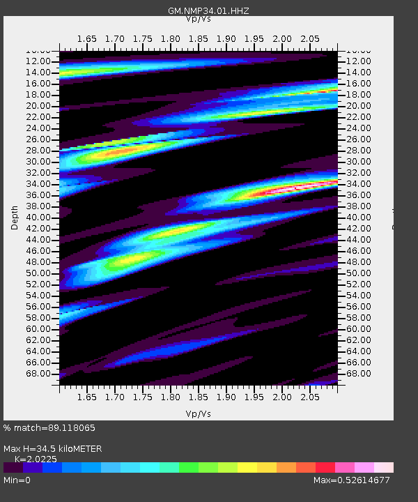
| Estimated Moho Depth: |
34.5 km |
| Estimated Crust Vp/Vs: |
2.02 |
| Assumed Crust Vp: |
6.129 km/s |
| Estimated Crust Vs: |
3.03 km/s |
| Estimated Crust Poisson's Ratio: |
0.34 |
|
| Radial Match: |
89.118065 % |
| Radial Bump: |
399 |
| Transverse Match: |
80.909546 % |
| Transverse Bump: |
400 |
| SOD ConfigId: |
24334971 |
| Insert Time: |
2021-04-03 09:27:17.955 +0000 |
| GWidth: |
2.5 |
| Max Bumps: |
400 |
| Tol: |
0.001 |
|

Signal To Noise
| Channel | StoN | STA | LTA |
| GM:NMP34:01:HHZ:20210320T09:21:53.844979Z | 4.8643236 | 1.8010509E-6 | 3.702572E-7 |
| GM:NMP34:01:HHN:20210320T09:21:53.844979Z | 1.6343868 | 4.6371164E-7 | 2.837221E-7 |
| GM:NMP34:01:HHE:20210320T09:21:53.844979Z | 0.57686806 | 3.8853108E-7 | 6.735181E-7 |
| Arrivals |
| Ps | 5.9 SECOND |
| PpPs | 17 SECOND |
| PsPs/PpSs | 23 SECOND |


