You are here: Home > Network List > GS - US Geological Survey Networks Stations List
> Station ID12 ID12, Stanley, ID > Earthquake Result Viewer
ID12 ID12, Stanley, ID - Earthquake Result Viewer
| Earthquake location: |
Near East Coast Of Honshu, Japan |
| Earthquake latitude/longitude: |
38.5/141.6 |
| Earthquake time(UTC): |
2021/03/20 (079) 09:09:45 GMT |
| Earthquake Depth: |
54 km |
| Earthquake Magnitude: |
7.0 Mww |
| Earthquake Catalog/Contributor: |
NEIC PDE/us |
|
| Network: |
GS US Geological Survey Networks |
| Station: |
ID12 ID12, Stanley, ID |
| Lat/Lon: |
44.21 N/114.97 W |
| Elevation: |
1958 m |
|
| Distance: |
72.6 deg |
| Az: |
47.153 deg |
| Baz: |
306.85 deg |
| Ray Param: |
0.053478558 |
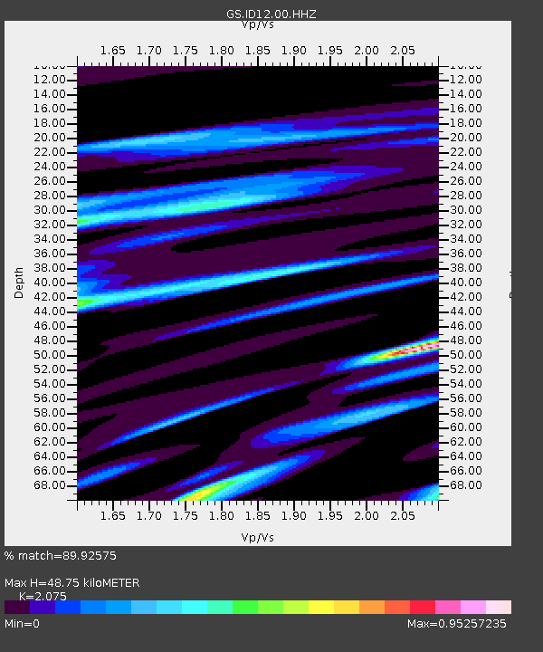
| Estimated Moho Depth: |
48.75 km |
| Estimated Crust Vp/Vs: |
2.08 |
| Assumed Crust Vp: |
6.577 km/s |
| Estimated Crust Vs: |
3.17 km/s |
| Estimated Crust Poisson's Ratio: |
0.35 |
|
| Radial Match: |
89.92575 % |
| Radial Bump: |
400 |
| Transverse Match: |
76.06342 % |
| Transverse Bump: |
400 |
| SOD ConfigId: |
24334971 |
| Insert Time: |
2021-04-03 09:27:57.980 +0000 |
| GWidth: |
2.5 |
| Max Bumps: |
400 |
| Tol: |
0.001 |
|

Signal To Noise
| Channel | StoN | STA | LTA |
| GS:ID12:00:HHZ:20210320T09:20:35.820016Z | 8.537751 | 1.7669913E-6 | 2.0696214E-7 |
| GS:ID12:00:HH1:20210320T09:20:35.820016Z | 1.8982542 | 5.925978E-7 | 3.1218042E-7 |
| GS:ID12:00:HH2:20210320T09:20:35.820016Z | 2.2812066 | 5.888757E-7 | 2.5814222E-7 |
| Arrivals |
| Ps | 8.2 SECOND |
| PpPs | 22 SECOND |
| PsPs/PpSs | 30 SECOND |


