You are here: Home > Network List > II - Global Seismograph Network (GSN - IRIS/IDA) Stations List
> Station COCO West Island, Cocos (Keeling) Islands > Earthquake Result Viewer
COCO West Island, Cocos (Keeling) Islands - Earthquake Result Viewer
| Earthquake location: |
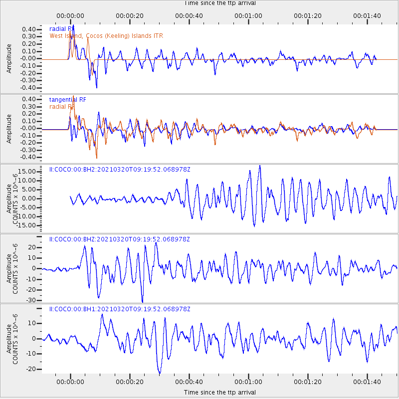
Near East Coast Of Honshu, Japan |
| Earthquake latitude/longitude: |
38.5/141.6 |
| Earthquake time(UTC): |
2021/03/20 (079) 09:09:45 GMT |
| Earthquake Depth: |
54 km |
| Earthquake Magnitude: |
7.0 Mww |
| Earthquake Catalog/Contributor: |
NEIC PDE/us |
|
| Network: |
II Global Seismograph Network (GSN - IRIS/IDA) |
| Station: |
COCO West Island, Cocos (Keeling) Islands |
| Lat/Lon: |
12.19 S/96.83 E |
| Elevation: |
1.0 m |
|
| Distance: |
65.5 deg |
| Az: |
229.183 deg |
| Baz: |
37.412 deg |
| Ray Param: |
0.058111563 |
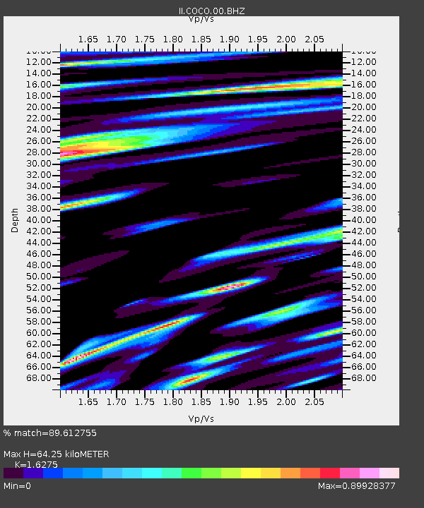
| Estimated Moho Depth: |
64.25 km |
| Estimated Crust Vp/Vs: |
1.63 |
| Assumed Crust Vp: |
4.24 km/s |
| Estimated Crust Vs: |
2.605 km/s |
| Estimated Crust Poisson's Ratio: |
0.20 |
|
| Radial Match: |
89.612755 % |
| Radial Bump: |
353 |
| Transverse Match: |
90.580635 % |
| Transverse Bump: |
400 |
| SOD ConfigId: |
24334971 |
| Insert Time: |
2021-04-03 09:28:26.796 +0000 |
| GWidth: |
2.5 |
| Max Bumps: |
400 |
| Tol: |
0.001 |
|
Signal To Noise
| Channel | StoN | STA | LTA |
| II:COCO:00:BHZ:20210320T09:19:52.068978Z | 8.119539 | 7.6073557E-6 | 9.3691966E-7 |
| II:COCO:00:BH1:20210320T09:19:52.068978Z | 1.8722233 | 2.8560185E-6 | 1.5254689E-6 |
| II:COCO:00:BH2:20210320T09:19:52.068978Z | 1.3648136 | 1.6339943E-6 | 1.1972289E-6 |
| Arrivals |
| Ps | 9.7 SECOND |
| PpPs | 39 SECOND |
| PsPs/PpSs | 49 SECOND |


