You are here: Home > Network List > GE - GEOFON Stations List
> Station MALT GEOFON/MedNet Station Malatya, Turkey > Earthquake Result Viewer
MALT GEOFON/MedNet Station Malatya, Turkey - Earthquake Result Viewer
| Earthquake location: |
East Of Kuril Islands |
| Earthquake latitude/longitude: |
46.4/154.5 |
| Earthquake time(UTC): |
2006/11/16 (320) 06:20:20 GMT |
| Earthquake Depth: |
9.0 km |
| Earthquake Magnitude: |
6.0 MB, 5.4 MS, 5.9 MW, 5.9 MW |
| Earthquake Catalog/Contributor: |
WHDF/NEIC |
|
| Network: |
GE GEOFON |
| Station: |
MALT GEOFON/MedNet Station Malatya, Turkey |
| Lat/Lon: |
38.31 N/38.43 E |
| Elevation: |
1120 m |
|
| Distance: |
78.1 deg |
| Az: |
313.754 deg |
| Baz: |
39.489 deg |
| Ray Param: |
0.049872592 |
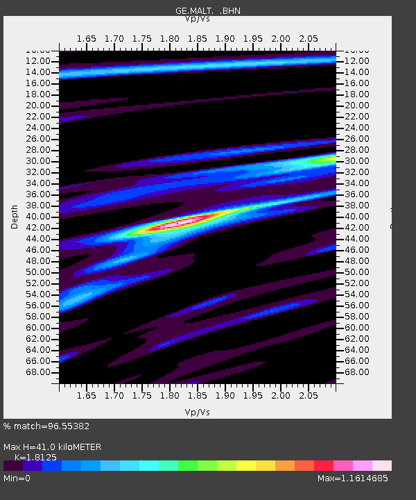
| Estimated Moho Depth: |
41.0 km |
| Estimated Crust Vp/Vs: |
1.81 |
| Assumed Crust Vp: |
6.35 km/s |
| Estimated Crust Vs: |
3.503 km/s |
| Estimated Crust Poisson's Ratio: |
0.28 |
|
| Radial Match: |
96.55382 % |
| Radial Bump: |
381 |
| Transverse Match: |
88.836754 % |
| Transverse Bump: |
400 |
| SOD ConfigId: |
2564 |
| Insert Time: |
2010-03-09 06:42:54.086 +0000 |
| GWidth: |
2.5 |
| Max Bumps: |
400 |
| Tol: |
0.001 |
|

Signal To Noise
| Channel | StoN | STA | LTA |
| GE:MALT: :BHN:20061116T06:31:48.582012Z | 0.93711144 | 4.400297E-8 | 4.695596E-8 |
| GE:MALT: :BHE:20061116T06:31:48.582012Z | 2.8800364 | 1.0662601E-7 | 3.7022453E-8 |
| GE:MALT: :BHZ:20061116T06:31:48.582012Z | 3.7594283 | 2.210715E-7 | 5.8804552E-8 |
| Arrivals |
| Ps | 5.4 SECOND |
| PpPs | 18 SECOND |
| PsPs/PpSs | 23 SECOND |


