You are here: Home > Network List > GE - GEOFON Stations List
> Station MALT GEOFON/MedNet Station Malatya, Turkey > Earthquake Result Viewer
MALT GEOFON/MedNet Station Malatya, Turkey - Earthquake Result Viewer
| Earthquake location: |
Kuril Islands |
| Earthquake latitude/longitude: |
46.6/153.3 |
| Earthquake time(UTC): |
2006/11/15 (319) 11:14:13 GMT |
| Earthquake Depth: |
10 km |
| Earthquake Magnitude: |
6.5 MB, 7.8 MS, 8.3 MW, 7.9 MW |
| Earthquake Catalog/Contributor: |
WHDF/NEIC |
|
| Network: |
GE GEOFON |
| Station: |
MALT GEOFON/MedNet Station Malatya, Turkey |
| Lat/Lon: |
38.31 N/38.43 E |
| Elevation: |
1120 m |
|
| Distance: |
77.3 deg |
| Az: |
312.973 deg |
| Baz: |
39.899 deg |
| Ray Param: |
0.050391212 |
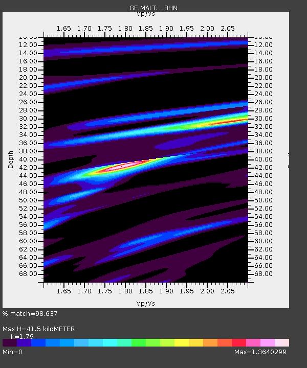
| Estimated Moho Depth: |
41.5 km |
| Estimated Crust Vp/Vs: |
1.79 |
| Assumed Crust Vp: |
6.35 km/s |
| Estimated Crust Vs: |
3.547 km/s |
| Estimated Crust Poisson's Ratio: |
0.27 |
|
| Radial Match: |
98.637 % |
| Radial Bump: |
271 |
| Transverse Match: |
93.7026 % |
| Transverse Bump: |
400 |
| SOD ConfigId: |
2564 |
| Insert Time: |
2010-03-09 06:42:59.056 +0000 |
| GWidth: |
2.5 |
| Max Bumps: |
400 |
| Tol: |
0.001 |
|

Signal To Noise
| Channel | StoN | STA | LTA |
| GE:MALT: :BHN:20061115T11:25:36.983025Z | 7.523245 | 1.1052009E-6 | 1.4690481E-7 |
| GE:MALT: :BHE:20061115T11:25:36.983025Z | 2.1972783 | 5.111028E-7 | 2.3260723E-7 |
| GE:MALT: :BHZ:20061115T11:25:36.983025Z | 10.28277 | 3.215866E-6 | 3.1274314E-7 |
| Arrivals |
| Ps | 5.3 SECOND |
| PpPs | 18 SECOND |
| PsPs/PpSs | 23 SECOND |


