You are here: Home > Network List > IU - Global Seismograph Network (GSN - IRIS/USGS) Stations List
> Station GRFO Grafenberg, Germany > Earthquake Result Viewer
GRFO Grafenberg, Germany - Earthquake Result Viewer
| Earthquake location: |
Near East Coast Of Honshu, Japan |
| Earthquake latitude/longitude: |
38.5/141.6 |
| Earthquake time(UTC): |
2021/03/20 (079) 09:09:45 GMT |
| Earthquake Depth: |
54 km |
| Earthquake Magnitude: |
7.0 Mww |
| Earthquake Catalog/Contributor: |
NEIC PDE/us |
|
| Network: |
IU Global Seismograph Network (GSN - IRIS/USGS) |
| Station: |
GRFO Grafenberg, Germany |
| Lat/Lon: |
49.69 N/11.22 E |
| Elevation: |
384 m |
|
| Distance: |
81.9 deg |
| Az: |
330.023 deg |
| Baz: |
37.148 deg |
| Ray Param: |
0.047162954 |
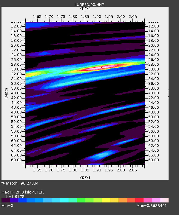
| Estimated Moho Depth: |
29.0 km |
| Estimated Crust Vp/Vs: |
1.92 |
| Assumed Crust Vp: |
6.182 km/s |
| Estimated Crust Vs: |
3.224 km/s |
| Estimated Crust Poisson's Ratio: |
0.31 |
|
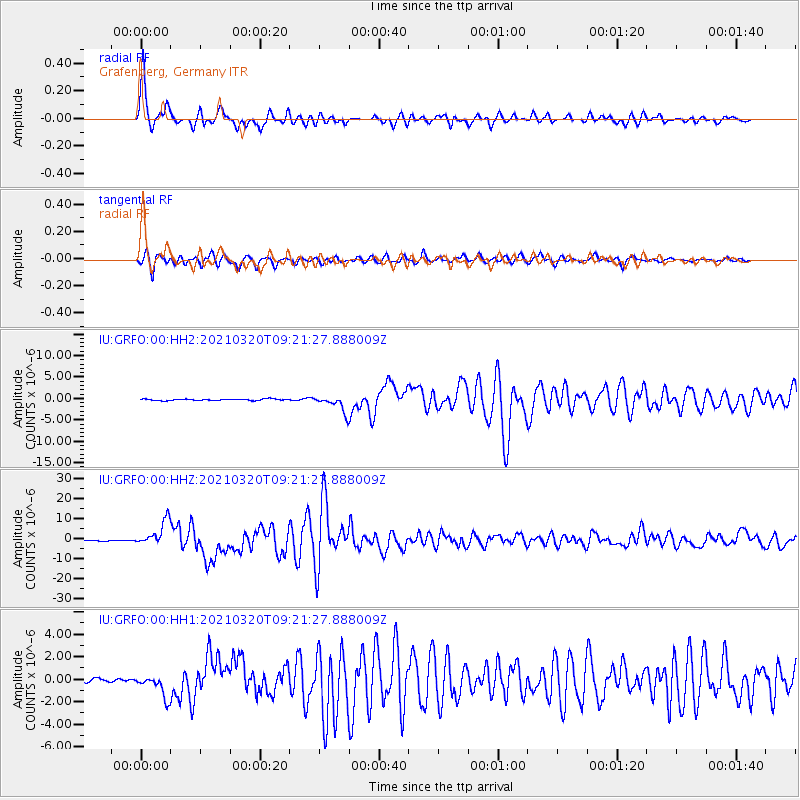
| Radial Match: |
96.27334 % |
| Radial Bump: |
357 |
| Transverse Match: |
94.739105 % |
| Transverse Bump: |
396 |
| SOD ConfigId: |
24334971 |
| Insert Time: |
2021-04-03 09:29:08.197 +0000 |
| GWidth: |
2.5 |
| Max Bumps: |
400 |
| Tol: |
0.001 |
|
Signal To Noise
| Channel | StoN | STA | LTA |
| IU:GRFO:00:HHZ:20210320T09:21:27.888009Z | 25.321016 | 6.1952665E-6 | 2.4466894E-7 |
| IU:GRFO:00:HH1:20210320T09:21:27.888009Z | 4.5218706 | 9.972013E-7 | 2.2052846E-7 |
| IU:GRFO:00:HH2:20210320T09:21:27.888009Z | 11.285679 | 1.8878238E-6 | 1.6727606E-7 |
| Arrivals |
| Ps | 4.4 SECOND |
| PpPs | 13 SECOND |
| PsPs/PpSs | 18 SECOND |


