You are here: Home > Network List > KO - Kandilli Observatory Digital Broadband Seismic Network Stations List
> Station GAZ Gaziantep-Turkey > Earthquake Result Viewer
GAZ Gaziantep-Turkey - Earthquake Result Viewer
| Earthquake location: |
Near East Coast Of Honshu, Japan |
| Earthquake latitude/longitude: |
38.5/141.6 |
| Earthquake time(UTC): |
2021/03/20 (079) 09:09:45 GMT |
| Earthquake Depth: |
54 km |
| Earthquake Magnitude: |
7.0 Mww |
| Earthquake Catalog/Contributor: |
NEIC PDE/us |
|
| Network: |
KO Kandilli Observatory Digital Broadband Seismic Network |
| Station: |
GAZ Gaziantep-Turkey |
| Lat/Lon: |
37.17 N/37.21 E |
| Elevation: |
992 m |
|
| Distance: |
77.5 deg |
| Az: |
307.575 deg |
| Baz: |
51.15 deg |
| Ray Param: |
0.050205924 |
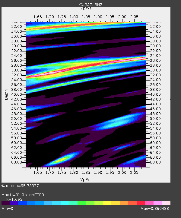
| Estimated Moho Depth: |
31.0 km |
| Estimated Crust Vp/Vs: |
1.70 |
| Assumed Crust Vp: |
6.247 km/s |
| Estimated Crust Vs: |
3.685 km/s |
| Estimated Crust Poisson's Ratio: |
0.23 |
|
| Radial Match: |
95.73377 % |
| Radial Bump: |
400 |
| Transverse Match: |
85.16785 % |
| Transverse Bump: |
400 |
| SOD ConfigId: |
24334971 |
| Insert Time: |
2021-04-03 09:29:34.222 +0000 |
| GWidth: |
2.5 |
| Max Bumps: |
400 |
| Tol: |
0.001 |
|

Signal To Noise
| Channel | StoN | STA | LTA |
| KO:GAZ: :BHZ:20210320T09:21:04.000008Z | 39.086235 | 4.0017244E-6 | 1.0238194E-7 |
| KO:GAZ: :BHN:20210320T09:21:04.000008Z | 12.683628 | 7.206066E-7 | 5.6813917E-8 |
| KO:GAZ: :BHE:20210320T09:21:04.000008Z | 7.620376 | 7.4208435E-7 | 9.738159E-8 |
| Arrivals |
| Ps | 3.6 SECOND |
| PpPs | 13 SECOND |
| PsPs/PpSs | 17 SECOND |


