You are here: Home > Network List > MB - Montana Regional Seismic Network Stations List
> Station BUT Butte, Montana > Earthquake Result Viewer
BUT Butte, Montana - Earthquake Result Viewer
| Earthquake location: |
Near East Coast Of Honshu, Japan |
| Earthquake latitude/longitude: |
38.5/141.6 |
| Earthquake time(UTC): |
2021/03/20 (079) 09:09:45 GMT |
| Earthquake Depth: |
54 km |
| Earthquake Magnitude: |
7.0 Mww |
| Earthquake Catalog/Contributor: |
NEIC PDE/us |
|
| Network: |
MB Montana Regional Seismic Network |
| Station: |
BUT Butte, Montana |
| Lat/Lon: |
46.01 N/112.56 W |
| Elevation: |
1758 m |
|
| Distance: |
72.8 deg |
| Az: |
44.566 deg |
| Baz: |
307.786 deg |
| Ray Param: |
0.05330036 |
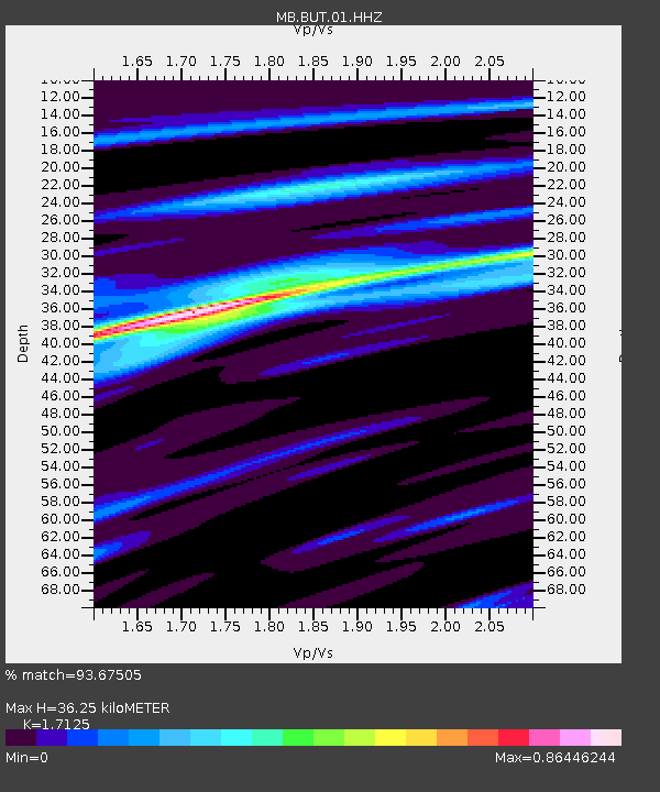
| Estimated Moho Depth: |
36.25 km |
| Estimated Crust Vp/Vs: |
1.71 |
| Assumed Crust Vp: |
6.353 km/s |
| Estimated Crust Vs: |
3.71 km/s |
| Estimated Crust Poisson's Ratio: |
0.24 |
|
| Radial Match: |
93.67505 % |
| Radial Bump: |
270 |
| Transverse Match: |
81.23741 % |
| Transverse Bump: |
400 |
| SOD ConfigId: |
24334971 |
| Insert Time: |
2021-04-03 09:30:18.873 +0000 |
| GWidth: |
2.5 |
| Max Bumps: |
400 |
| Tol: |
0.001 |
|

Signal To Noise
| Channel | StoN | STA | LTA |
| MB:BUT:01:HHZ:20210320T09:20:37.409981Z | 13.351972 | 4.1884978E-6 | 3.1369882E-7 |
| MB:BUT:01:HHN:20210320T09:20:37.409981Z | 2.6272976 | 1.1997781E-6 | 4.5665865E-7 |
| MB:BUT:01:HHE:20210320T09:20:37.409981Z | 3.6416888 | 1.8357439E-6 | 5.0409136E-7 |
| Arrivals |
| Ps | 4.2 SECOND |
| PpPs | 15 SECOND |
| PsPs/PpSs | 19 SECOND |


