You are here: Home > Network List > MB - Montana Regional Seismic Network Stations List
> Station HLMT Hummingbird Lane > Earthquake Result Viewer
HLMT Hummingbird Lane - Earthquake Result Viewer
| Earthquake location: |
Near East Coast Of Honshu, Japan |
| Earthquake latitude/longitude: |
38.5/141.6 |
| Earthquake time(UTC): |
2021/03/20 (079) 09:09:45 GMT |
| Earthquake Depth: |
54 km |
| Earthquake Magnitude: |
7.0 Mww |
| Earthquake Catalog/Contributor: |
NEIC PDE/us |
|
| Network: |
MB Montana Regional Seismic Network |
| Station: |
HLMT Hummingbird Lane |
| Lat/Lon: |
45.90 N/112.56 W |
| Elevation: |
1843 m |
|
| Distance: |
72.9 deg |
| Az: |
44.654 deg |
| Baz: |
307.813 deg |
| Ray Param: |
0.053254995 |
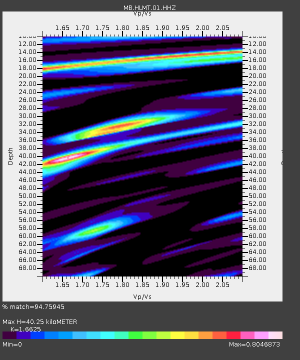
| Estimated Moho Depth: |
40.25 km |
| Estimated Crust Vp/Vs: |
1.66 |
| Assumed Crust Vp: |
6.577 km/s |
| Estimated Crust Vs: |
3.956 km/s |
| Estimated Crust Poisson's Ratio: |
0.22 |
|
| Radial Match: |
94.75945 % |
| Radial Bump: |
331 |
| Transverse Match: |
86.39798 % |
| Transverse Bump: |
400 |
| SOD ConfigId: |
24334971 |
| Insert Time: |
2021-04-03 09:30:24.286 +0000 |
| GWidth: |
2.5 |
| Max Bumps: |
400 |
| Tol: |
0.001 |
|

Signal To Noise
| Channel | StoN | STA | LTA |
| MB:HLMT:01:HHZ:20210320T09:20:37.799996Z | 7.914083 | 2.4497822E-6 | 3.095472E-7 |
| MB:HLMT:01:HHN:20210320T09:20:37.799996Z | 1.7184715 | 4.7779434E-7 | 2.7803446E-7 |
| MB:HLMT:01:HHE:20210320T09:20:37.799996Z | 2.1049905 | 8.328728E-7 | 3.956658E-7 |
| Arrivals |
| Ps | 4.2 SECOND |
| PpPs | 16 SECOND |
| PsPs/PpSs | 20 SECOND |


