You are here: Home > Network List > N4 - Central and EAstern US Network Stations List
> Station BGNE Belgrade, NE, USA > Earthquake Result Viewer
BGNE Belgrade, NE, USA - Earthquake Result Viewer
| Earthquake location: |
Near East Coast Of Honshu, Japan |
| Earthquake latitude/longitude: |
38.5/141.6 |
| Earthquake time(UTC): |
2021/03/20 (079) 09:09:45 GMT |
| Earthquake Depth: |
54 km |
| Earthquake Magnitude: |
7.0 Mww |
| Earthquake Catalog/Contributor: |
NEIC PDE/us |
|
| Network: |
N4 Central and EAstern US Network |
| Station: |
BGNE Belgrade, NE, USA |
| Lat/Lon: |
41.41 N/98.15 W |
| Elevation: |
573 m |
|
| Distance: |
83.6 deg |
| Az: |
40.834 deg |
| Baz: |
316.977 deg |
| Ray Param: |
0.045954883 |
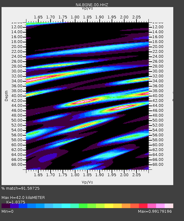
| Estimated Moho Depth: |
42.0 km |
| Estimated Crust Vp/Vs: |
1.84 |
| Assumed Crust Vp: |
6.53 km/s |
| Estimated Crust Vs: |
3.554 km/s |
| Estimated Crust Poisson's Ratio: |
0.29 |
|
| Radial Match: |
91.59725 % |
| Radial Bump: |
400 |
| Transverse Match: |
81.56197 % |
| Transverse Bump: |
400 |
| SOD ConfigId: |
24334971 |
| Insert Time: |
2021-04-03 09:30:55.459 +0000 |
| GWidth: |
2.5 |
| Max Bumps: |
400 |
| Tol: |
0.001 |
|

Signal To Noise
| Channel | StoN | STA | LTA |
| N4:BGNE:00:HHZ:20210320T09:21:36.830025Z | 5.591359 | 2.783294E-6 | 4.9778487E-7 |
| N4:BGNE:00:HH1:20210320T09:21:36.830025Z | 1.4453589 | 1.0762205E-6 | 7.446044E-7 |
| N4:BGNE:00:HH2:20210320T09:21:36.830025Z | 1.1992317 | 8.452629E-7 | 7.0483696E-7 |
| Arrivals |
| Ps | 5.5 SECOND |
| PpPs | 18 SECOND |
| PsPs/PpSs | 23 SECOND |


