You are here: Home > Network List > N4 - Central and EAstern US Network Stations List
> Station O52A Adamsville, OH, USA > Earthquake Result Viewer
O52A Adamsville, OH, USA - Earthquake Result Viewer
| Earthquake location: |
Near East Coast Of Honshu, Japan |
| Earthquake latitude/longitude: |
38.5/141.6 |
| Earthquake time(UTC): |
2021/03/20 (079) 09:09:45 GMT |
| Earthquake Depth: |
54 km |
| Earthquake Magnitude: |
7.0 Mww |
| Earthquake Catalog/Contributor: |
NEIC PDE/us |
|
| Network: |
N4 Central and EAstern US Network |
| Station: |
O52A Adamsville, OH, USA |
| Lat/Lon: |
40.12 N/81.84 W |
| Elevation: |
331 m |
|
| Distance: |
92.3 deg |
| Az: |
31.853 deg |
| Baz: |
327.306 deg |
| Ray Param: |
0.04146855 |
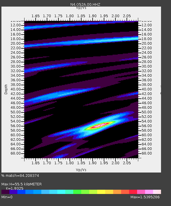
| Estimated Moho Depth: |
55.5 km |
| Estimated Crust Vp/Vs: |
1.93 |
| Assumed Crust Vp: |
6.483 km/s |
| Estimated Crust Vs: |
3.355 km/s |
| Estimated Crust Poisson's Ratio: |
0.32 |
|
| Radial Match: |
84.208374 % |
| Radial Bump: |
393 |
| Transverse Match: |
66.02803 % |
| Transverse Bump: |
400 |
| SOD ConfigId: |
24334971 |
| Insert Time: |
2021-04-03 09:32:08.528 +0000 |
| GWidth: |
2.5 |
| Max Bumps: |
400 |
| Tol: |
0.001 |
|

Signal To Noise
| Channel | StoN | STA | LTA |
| N4:O52A:00:HHZ:20210320T09:22:18.120003Z | 3.2449093 | 1.8309786E-6 | 5.642619E-7 |
| N4:O52A:00:HH1:20210320T09:22:18.120003Z | 2.1802995 | 8.9038053E-7 | 4.0837534E-7 |
| N4:O52A:00:HH2:20210320T09:22:18.120003Z | 1.0076098 | 7.9855E-7 | 7.92519E-7 |
| Arrivals |
| Ps | 8.1 SECOND |
| PpPs | 25 SECOND |
| PsPs/PpSs | 33 SECOND |


