You are here: Home > Network List > N4 - Central and EAstern US Network Stations List
> Station SUSD Miller, SD, USA > Earthquake Result Viewer
SUSD Miller, SD, USA - Earthquake Result Viewer
| Earthquake location: |
Near East Coast Of Honshu, Japan |
| Earthquake latitude/longitude: |
38.5/141.6 |
| Earthquake time(UTC): |
2021/03/20 (079) 09:09:45 GMT |
| Earthquake Depth: |
54 km |
| Earthquake Magnitude: |
7.0 Mww |
| Earthquake Catalog/Contributor: |
NEIC PDE/us |
|
| Network: |
N4 Central and EAstern US Network |
| Station: |
SUSD Miller, SD, USA |
| Lat/Lon: |
44.44 N/98.96 W |
| Elevation: |
520 m |
|
| Distance: |
81.0 deg |
| Az: |
39.165 deg |
| Baz: |
316.208 deg |
| Ray Param: |
0.047783963 |
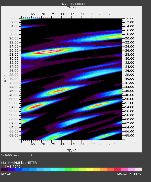
| Estimated Moho Depth: |
26.5 km |
| Estimated Crust Vp/Vs: |
1.73 |
| Assumed Crust Vp: |
6.53 km/s |
| Estimated Crust Vs: |
3.78 km/s |
| Estimated Crust Poisson's Ratio: |
0.25 |
|
| Radial Match: |
96.56364 % |
| Radial Bump: |
366 |
| Transverse Match: |
94.334564 % |
| Transverse Bump: |
387 |
| SOD ConfigId: |
24334971 |
| Insert Time: |
2021-04-03 09:32:43.753 +0000 |
| GWidth: |
2.5 |
| Max Bumps: |
400 |
| Tol: |
0.001 |
|

Signal To Noise
| Channel | StoN | STA | LTA |
| N4:SUSD:00:HHZ:20210320T09:21:23.260018Z | 11.916703 | 3.2934522E-6 | 2.7637276E-7 |
| N4:SUSD:00:HH1:20210320T09:21:23.260018Z | 2.5964584 | 1.4736152E-6 | 5.6754817E-7 |
| N4:SUSD:00:HH2:20210320T09:21:23.260018Z | 2.9298158 | 1.1247695E-6 | 3.8390448E-7 |
| Arrivals |
| Ps | 3.0 SECOND |
| PpPs | 11 SECOND |
| PsPs/PpSs | 14 SECOND |


