You are here: Home > Network List > N4 - Central and EAstern US Network Stations List
> Station Z35B Perchaven, Sanger, TX, USA > Earthquake Result Viewer
Z35B Perchaven, Sanger, TX, USA - Earthquake Result Viewer
| Earthquake location: |
Near East Coast Of Honshu, Japan |
| Earthquake latitude/longitude: |
38.5/141.6 |
| Earthquake time(UTC): |
2021/03/20 (079) 09:09:45 GMT |
| Earthquake Depth: |
54 km |
| Earthquake Magnitude: |
7.0 Mww |
| Earthquake Catalog/Contributor: |
NEIC PDE/us |
|
| Network: |
N4 Central and EAstern US Network |
| Station: |
Z35B Perchaven, Sanger, TX, USA |
| Lat/Lon: |
33.33 N/97.25 W |
| Elevation: |
234 m |
|
| Distance: |
90.1 deg |
| Az: |
45.771 deg |
| Baz: |
317.793 deg |
| Ray Param: |
0.041718744 |
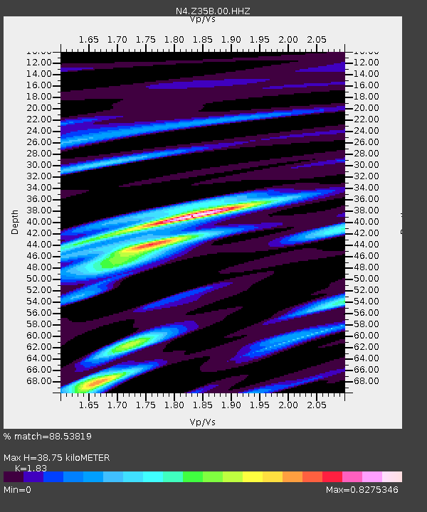
| Estimated Moho Depth: |
38.75 km |
| Estimated Crust Vp/Vs: |
1.83 |
| Assumed Crust Vp: |
6.38 km/s |
| Estimated Crust Vs: |
3.487 km/s |
| Estimated Crust Poisson's Ratio: |
0.29 |
|
| Radial Match: |
88.53819 % |
| Radial Bump: |
353 |
| Transverse Match: |
73.484825 % |
| Transverse Bump: |
400 |
| SOD ConfigId: |
24334971 |
| Insert Time: |
2021-04-03 09:33:12.499 +0000 |
| GWidth: |
2.5 |
| Max Bumps: |
400 |
| Tol: |
0.001 |
|

Signal To Noise
| Channel | StoN | STA | LTA |
| N4:Z35B:00:HHZ:20210320T09:22:07.950021Z | 4.5177736 | 1.7110009E-6 | 3.7872655E-7 |
| N4:Z35B:00:HH1:20210320T09:22:07.950021Z | 3.1848795 | 6.2121273E-7 | 1.9505062E-7 |
| N4:Z35B:00:HH2:20210320T09:22:07.950021Z | 0.95896107 | 4.1201116E-7 | 4.2964325E-7 |
| Arrivals |
| Ps | 5.1 SECOND |
| PpPs | 17 SECOND |
| PsPs/PpSs | 22 SECOND |


